You are here: Home > Network List > II - Global Seismograph Network (GSN - IRIS/IDA) Stations List
> Station WRAB Tennant Creek, NT, Australia > Earthquake Result Viewer
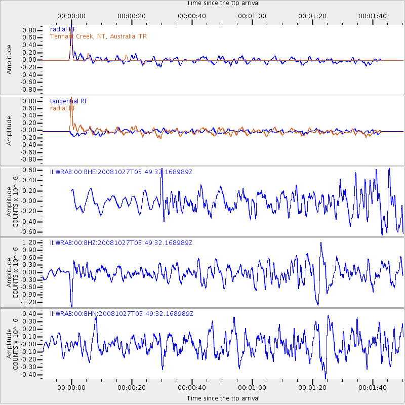
WRAB Tennant Creek, NT, Australia - Earthquake Result Viewer
*The percent match for this event was below the threshold and hence no stack was calculated.
| Earthquake location: |
Vanuatu Islands |
| Earthquake latitude/longitude: |
-14.6/167.2 |
| Earthquake time(UTC): |
2008/10/27 (301) 05:43:50 GMT |
| Earthquake Depth: |
129 km |
| Earthquake Magnitude: |
5.6 MW, 5.2 MB, 5.6 MW |
| Earthquake Catalog/Contributor: |
WHDF/NEIC |
|
| Network: |
II Global Seismograph Network (GSN - IRIS/IDA) |
| Station: |
WRAB Tennant Creek, NT, Australia |
| Lat/Lon: |
19.93 S/134.36 E |
| Elevation: |
366 m |
|
| Distance: |
31.7 deg |
| Az: |
255.746 deg |
| Baz: |
85.699 deg |
| Ray Param: |
$rayparam |
*The percent match for this event was below the threshold and hence was not used in the summary stack. |
|
| Radial Match: |
76.85583 % |
| Radial Bump: |
400 |
| Transverse Match: |
51.640316 % |
| Transverse Bump: |
400 |
| SOD ConfigId: |
2560 |
| Insert Time: |
2010-03-01 23:28:32.040 +0000 |
| GWidth: |
2.5 |
| Max Bumps: |
400 |
| Tol: |
0.001 |
|
Signal To Noise
| Channel | StoN | STA | LTA |
| II:WRAB:00:BHZ:20081027T05:49:32.168989Z | 3.2117004 | 4.547072E-7 | 1.4157833E-7 |
| II:WRAB:00:BHN:20081027T05:49:32.168989Z | 0.50152785 | 6.909506E-8 | 1.3776913E-7 |
| II:WRAB:00:BHE:20081027T05:49:32.168989Z | 1.7647295 | 2.2852315E-7 | 1.2949472E-7 |
| Arrivals |
| Ps | |
| PpPs | |
| PsPs/PpSs | |


