You are here: Home > Network List > II - Global Seismograph Network (GSN - IRIS/IDA) Stations List
> Station WRAB Tennant Creek, NT, Australia > Earthquake Result Viewer
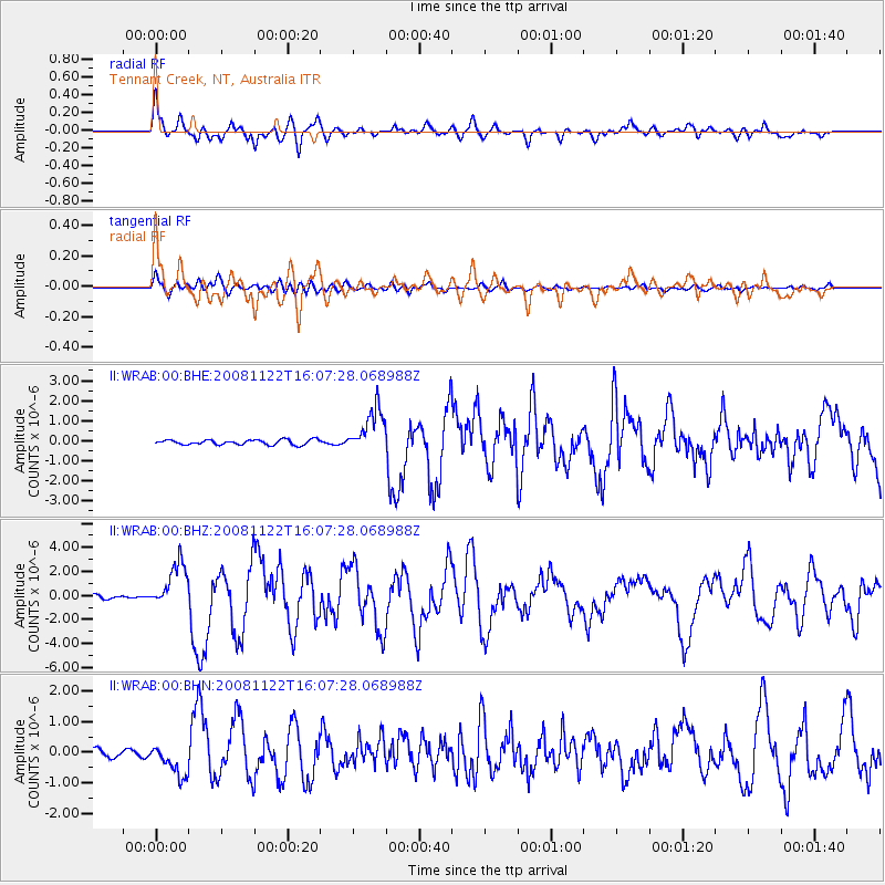
WRAB Tennant Creek, NT, Australia - Earthquake Result Viewer
*The percent match for this event was below the threshold and hence no stack was calculated.
| Earthquake location: |
Southern Sumatra, Indonesia |
| Earthquake latitude/longitude: |
-4.3/101.3 |
| Earthquake time(UTC): |
2008/11/22 (327) 16:01:01 GMT |
| Earthquake Depth: |
24 km |
| Earthquake Magnitude: |
5.9 MB, 6.4 MW, 6.3 MW |
| Earthquake Catalog/Contributor: |
WHDF/NEIC |
|
| Network: |
II Global Seismograph Network (GSN - IRIS/IDA) |
| Station: |
WRAB Tennant Creek, NT, Australia |
| Lat/Lon: |
19.93 S/134.36 E |
| Elevation: |
366 m |
|
| Distance: |
35.8 deg |
| Az: |
118.468 deg |
| Baz: |
291.294 deg |
| Ray Param: |
$rayparam |
*The percent match for this event was below the threshold and hence was not used in the summary stack. |
|
| Radial Match: |
75.62085 % |
| Radial Bump: |
400 |
| Transverse Match: |
77.42775 % |
| Transverse Bump: |
400 |
| SOD ConfigId: |
2658 |
| Insert Time: |
2010-03-01 23:28:47.780 +0000 |
| GWidth: |
2.5 |
| Max Bumps: |
400 |
| Tol: |
0.001 |
|
Signal To Noise
| Channel | StoN | STA | LTA |
| II:WRAB:00:BHZ:20081122T16:07:28.068988Z | 8.659564 | 1.9088088E-6 | 2.2042782E-7 |
| II:WRAB:00:BHN:20081122T16:07:28.068988Z | 4.238203 | 5.3222743E-7 | 1.2557857E-7 |
| II:WRAB:00:BHE:20081122T16:07:28.068988Z | 9.129624 | 1.113496E-6 | 1.2196514E-7 |
| Arrivals |
| Ps | |
| PpPs | |
| PsPs/PpSs | |


