You are here: Home > Network List > II - Global Seismograph Network (GSN - IRIS/IDA) Stations List
> Station WRAB Tennant Creek, NT, Australia > Earthquake Result Viewer
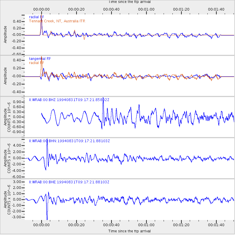
WRAB Tennant Creek, NT, Australia - Earthquake Result Viewer
*The percent match for this event was below the threshold and hence no stack was calculated.
| Earthquake location: |
Hokkaido, Japan Region |
| Earthquake latitude/longitude: |
43.7/146.0 |
| Earthquake time(UTC): |
1994/08/31 (243) 09:07:26 GMT |
| Earthquake Depth: |
80 km |
| Earthquake Magnitude: |
5.9 MB, 6.2 UNKNOWN, 6.2 MW |
| Earthquake Catalog/Contributor: |
WHDF/NEIC |
|
| Network: |
II Global Seismograph Network (GSN - IRIS/IDA) |
| Station: |
WRAB Tennant Creek, NT, Australia |
| Lat/Lon: |
19.93 S/134.36 E |
| Elevation: |
366 m |
|
| Distance: |
64.2 deg |
| Az: |
192.16 deg |
| Baz: |
9.345 deg |
| Ray Param: |
$rayparam |
*The percent match for this event was below the threshold and hence was not used in the summary stack. |
|
| Radial Match: |
59.717224 % |
| Radial Bump: |
380 |
| Transverse Match: |
62.589344 % |
| Transverse Bump: |
400 |
| SOD ConfigId: |
4480 |
| Insert Time: |
2010-03-01 23:28:49.503 +0000 |
| GWidth: |
2.5 |
| Max Bumps: |
400 |
| Tol: |
0.001 |
|
Signal To Noise
| Channel | StoN | STA | LTA |
| II:WRAB:00:BHN:19940831T09:17:21.88103Z | 9.138848 | 2.2247973E-6 | 2.4344396E-7 |
| II:WRAB:00:BHE:19940831T09:17:21.88103Z | 6.298295 | 1.1191083E-6 | 1.7768434E-7 |
| II:WRAB:00:BHZ:19940831T09:17:21.85802Z | 1.0171397 | 2.397565E-7 | 2.3571641E-7 |
| Arrivals |
| Ps | |
| PpPs | |
| PsPs/PpSs | |


