You are here: Home > Network List > II - Global Seismograph Network (GSN - IRIS/IDA) Stations List
> Station WRAB Tennant Creek, NT, Australia > Earthquake Result Viewer
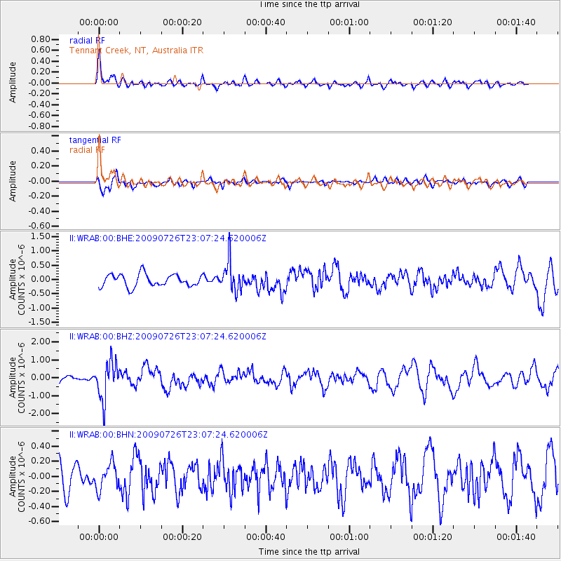
WRAB Tennant Creek, NT, Australia - Earthquake Result Viewer
*The percent match for this event was below the threshold and hence no stack was calculated.
| Earthquake location: |
Vanuatu Islands |
| Earthquake latitude/longitude: |
-17.8/168.1 |
| Earthquake time(UTC): |
2009/07/26 (207) 23:01:31 GMT |
| Earthquake Depth: |
25 km |
| Earthquake Magnitude: |
5.8 MB, 5.9 MW, 5.7 MW |
| Earthquake Catalog/Contributor: |
WHDF/NEIC |
|
| Network: |
II Global Seismograph Network (GSN - IRIS/IDA) |
| Station: |
WRAB Tennant Creek, NT, Australia |
| Lat/Lon: |
19.93 S/134.36 E |
| Elevation: |
366 m |
|
| Distance: |
32.0 deg |
| Az: |
260.672 deg |
| Baz: |
91.792 deg |
| Ray Param: |
$rayparam |
*The percent match for this event was below the threshold and hence was not used in the summary stack. |
|
| Radial Match: |
69.88923 % |
| Radial Bump: |
400 |
| Transverse Match: |
62.656506 % |
| Transverse Bump: |
400 |
| SOD ConfigId: |
2622 |
| Insert Time: |
2010-03-01 23:28:50.531 +0000 |
| GWidth: |
2.5 |
| Max Bumps: |
400 |
| Tol: |
0.001 |
|
Signal To Noise
| Channel | StoN | STA | LTA |
| II:WRAB:00:BHZ:20090726T23:07:24.620006Z | 3.4759092 | 1.06882E-6 | 3.0749365E-7 |
| II:WRAB:00:BHN:20090726T23:07:24.620006Z | 0.82513636 | 1.7497781E-7 | 2.1205926E-7 |
| II:WRAB:00:BHE:20090726T23:07:24.620006Z | 2.526968 | 5.410287E-7 | 2.1410193E-7 |
| Arrivals |
| Ps | |
| PpPs | |
| PsPs/PpSs | |


