You are here: Home > Network List > II - Global Seismograph Network (GSN - IRIS/IDA) Stations List
> Station WRAB Tennant Creek, NT, Australia > Earthquake Result Viewer
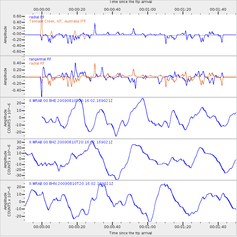
WRAB Tennant Creek, NT, Australia - Earthquake Result Viewer
*The percent match for this event was below the threshold and hence no stack was calculated.
| Earthquake location: |
Near S. Coast Of Honshu, Japan |
| Earthquake latitude/longitude: |
34.7/138.3 |
| Earthquake time(UTC): |
2009/08/10 (222) 20:07:09 GMT |
| Earthquake Depth: |
40 km |
| Earthquake Magnitude: |
6.1 MB |
| Earthquake Catalog/Contributor: |
WHDF/NEIC |
|
| Network: |
II Global Seismograph Network (GSN - IRIS/IDA) |
| Station: |
WRAB Tennant Creek, NT, Australia |
| Lat/Lon: |
19.93 S/134.36 E |
| Elevation: |
366 m |
|
| Distance: |
54.5 deg |
| Az: |
184.513 deg |
| Baz: |
3.949 deg |
| Ray Param: |
$rayparam |
*The percent match for this event was below the threshold and hence was not used in the summary stack. |
|
| Radial Match: |
74.35325 % |
| Radial Bump: |
400 |
| Transverse Match: |
58.61858 % |
| Transverse Bump: |
400 |
| SOD ConfigId: |
2622 |
| Insert Time: |
2010-03-01 23:28:52.751 +0000 |
| GWidth: |
2.5 |
| Max Bumps: |
400 |
| Tol: |
0.001 |
|
Signal To Noise
| Channel | StoN | STA | LTA |
| II:WRAB:00:BHZ:20090810T20:16:02.169021Z | 1.402187 | 1.1131207E-5 | 7.938462E-6 |
| II:WRAB:00:BHN:20090810T20:16:02.169021Z | 1.2139479 | 9.402916E-6 | 7.745733E-6 |
| II:WRAB:00:BHE:20090810T20:16:02.169021Z | 0.73977196 | 8.639124E-6 | 1.1678089E-5 |
| Arrivals |
| Ps | |
| PpPs | |
| PsPs/PpSs | |


