You are here: Home > Network List > TA - USArray Transportable Network (new EarthScope stations) Stations List
> Station H45A Beulah, MI, USA > Earthquake Result Viewer
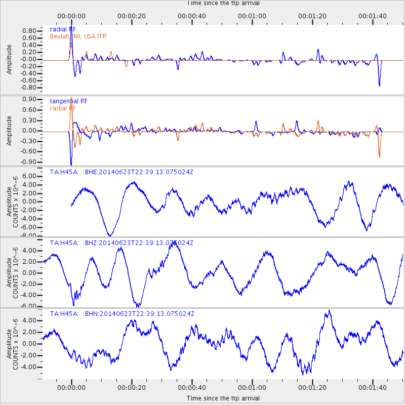
H45A Beulah, MI, USA - Earthquake Result Viewer
*The percent match for this event was below the threshold and hence no stack was calculated.
| Earthquake location: |
Rat Islands, Aleutian Islands |
| Earthquake latitude/longitude: |
52.0/178.6 |
| Earthquake time(UTC): |
2014/06/23 (174) 22:29:51 GMT |
| Earthquake Depth: |
103 km |
| Earthquake Magnitude: |
5.9 MB |
| Earthquake Catalog/Contributor: |
NEIC PDE/NEIC COMCAT |
|
| Network: |
TA USArray Transportable Network (new EarthScope stations) |
| Station: |
H45A Beulah, MI, USA |
| Lat/Lon: |
44.62 N/86.04 W |
| Elevation: |
242 m |
|
| Distance: |
59.4 deg |
| Az: |
55.646 deg |
| Baz: |
314.323 deg |
| Ray Param: |
$rayparam |
*The percent match for this event was below the threshold and hence was not used in the summary stack. |
|
| Radial Match: |
71.910255 % |
| Radial Bump: |
400 |
| Transverse Match: |
58.97714 % |
| Transverse Bump: |
362 |
| SOD ConfigId: |
739768 |
| Insert Time: |
2014-07-08 00:32:07.450 +0000 |
| GWidth: |
2.5 |
| Max Bumps: |
400 |
| Tol: |
0.001 |
|
Signal To Noise
| Channel | StoN | STA | LTA |
| TA:H45A: :BHZ:20140623T22:39:13.075024Z | 1.8784593 | 3.4528023E-6 | 1.8381032E-6 |
| TA:H45A: :BHN:20140623T22:39:13.075024Z | 3.5604916 | 3.0235287E-6 | 8.4918855E-7 |
| TA:H45A: :BHE:20140623T22:39:13.075024Z | 0.52539307 | 1.9743163E-6 | 3.7577893E-6 |
| Arrivals |
| Ps | |
| PpPs | |
| PsPs/PpSs | |


