You are here: Home > Network List > TA - USArray Transportable Network (new EarthScope stations) Stations List
> Station K49A Clarkson, MI, USA > Earthquake Result Viewer
K49A Clarkson, MI, USA - Earthquake Result Viewer

| Earthquake location: |
Rat Islands, Aleutian Islands |
| Earthquake latitude/longitude: |
52.0/178.6 |
| Earthquake time(UTC): |
2014/06/23 (174) 22:29:51 GMT |
| Earthquake Depth: |
103 km |
| Earthquake Magnitude: |
5.9 MB |
| Earthquake Catalog/Contributor: |
NEIC PDE/NEIC COMCAT |
|
| Network: |
TA USArray Transportable Network (new EarthScope stations) |
| Station: |
K49A Clarkson, MI, USA |
| Lat/Lon: |
42.78 N/83.46 W |
| Elevation: |
336 m |
|
| Distance: |
62.1 deg |
| Az: |
55.604 deg |
| Baz: |
316.085 deg |
| Ray Param: |
0.060177505 |
| Estimated Moho Depth: |
35.5 km |
| Estimated Crust Vp/Vs: |
2.09 |
| Assumed Crust Vp: |
6.483 km/s |
| Estimated Crust Vs: |
3.102 km/s |
| Estimated Crust Poisson's Ratio: |
0.35 |
|
| Radial Match: |
80.63465 % |
| Radial Bump: |
385 |
| Transverse Match: |
47.72694 % |
| Transverse Bump: |
400 |
| SOD ConfigId: |
739768 |
| Insert Time: |
2014-07-08 00:33:11.188 +0000 |
| GWidth: |
2.5 |
| Max Bumps: |
400 |
| Tol: |
0.001 |
|
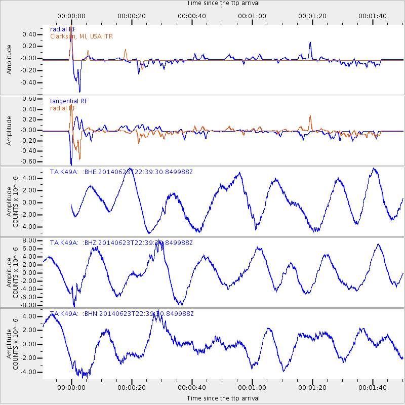
Signal To Noise
| Channel | StoN | STA | LTA |
| TA:K49A: :BHZ:20140623T22:39:30.849988Z | 1.7277426 | 4.8291186E-6 | 2.7950452E-6 |
| TA:K49A: :BHN:20140623T22:39:30.849988Z | 1.6194127 | 3.827049E-6 | 2.3632329E-6 |
| TA:K49A: :BHE:20140623T22:39:30.849988Z | 0.82050997 | 1.9163535E-6 | 2.335564E-6 |
| Arrivals |
| Ps | 6.2 SECOND |
| PpPs | 16 SECOND |
| PsPs/PpSs | 22 SECOND |


