You are here: Home > Network List > TA - USArray Transportable Network (new EarthScope stations) Stations List
> Station M61A Granite Springs, NY, USA > Earthquake Result Viewer
M61A Granite Springs, NY, USA - Earthquake Result Viewer
| Earthquake location: |
Rat Islands, Aleutian Islands |
| Earthquake latitude/longitude: |
52.0/178.6 |
| Earthquake time(UTC): |
2014/06/23 (174) 22:29:51 GMT |
| Earthquake Depth: |
103 km |
| Earthquake Magnitude: |
5.9 MB |
| Earthquake Catalog/Contributor: |
NEIC PDE/NEIC COMCAT |
|
| Network: |
TA USArray Transportable Network (new EarthScope stations) |
| Station: |
M61A Granite Springs, NY, USA |
| Lat/Lon: |
41.31 N/73.77 W |
| Elevation: |
190 m |
|
| Distance: |
68.0 deg |
| Az: |
50.743 deg |
| Baz: |
320.503 deg |
| Ray Param: |
0.056345247 |
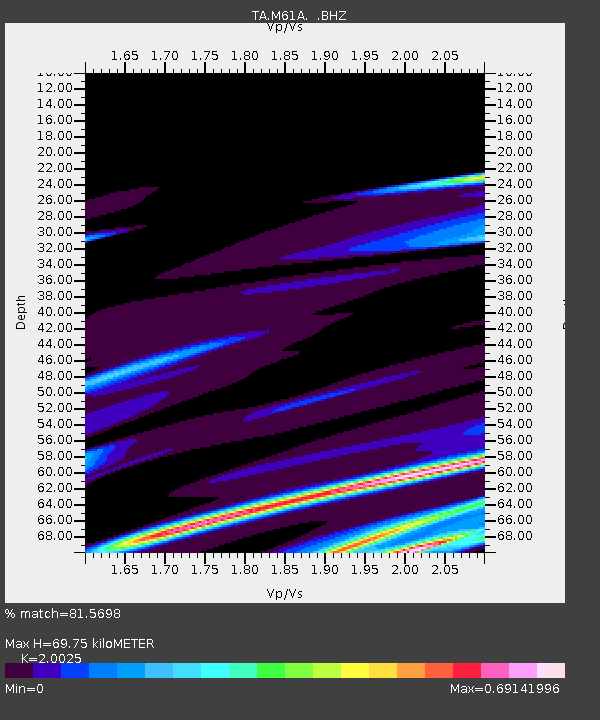
| Estimated Moho Depth: |
69.75 km |
| Estimated Crust Vp/Vs: |
2.00 |
| Assumed Crust Vp: |
6.472 km/s |
| Estimated Crust Vs: |
3.232 km/s |
| Estimated Crust Poisson's Ratio: |
0.33 |
|
| Radial Match: |
81.5698 % |
| Radial Bump: |
400 |
| Transverse Match: |
51.882366 % |
| Transverse Bump: |
400 |
| SOD ConfigId: |
739768 |
| Insert Time: |
2014-07-08 00:34:01.999 +0000 |
| GWidth: |
2.5 |
| Max Bumps: |
400 |
| Tol: |
0.001 |
|

Signal To Noise
| Channel | StoN | STA | LTA |
| TA:M61A: :BHZ:20140623T22:40:08.925Z | 0.78077286 | 4.114029E-6 | 5.269175E-6 |
| TA:M61A: :BHN:20140623T22:40:08.925Z | 0.37124366 | 7.6404353E-7 | 2.058065E-6 |
| TA:M61A: :BHE:20140623T22:40:08.925Z | 2.1690636 | 5.974601E-6 | 2.7544609E-6 |
| Arrivals |
| Ps | 11 SECOND |
| PpPs | 31 SECOND |
| PsPs/PpSs | 42 SECOND |


