You are here: Home > Network List > CI - Caltech Regional Seismic Network Stations List
> Station MPM Manuel Prospect Mine, California, USA > Earthquake Result Viewer
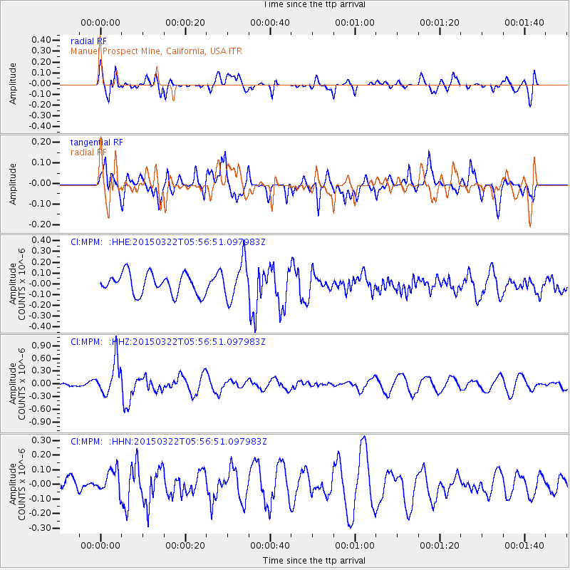
MPM Manuel Prospect Mine, California, USA - Earthquake Result Viewer
*The percent match for this event was below the threshold and hence no stack was calculated.
| Earthquake location: |
Fiji Islands Region |
| Earthquake latitude/longitude: |
-17.9/-178.4 |
| Earthquake time(UTC): |
2015/03/22 (081) 05:46:22 GMT |
| Earthquake Depth: |
616 km |
| Earthquake Magnitude: |
6.1 MW, 5.3 mb |
| Earthquake Catalog/Contributor: |
ISC/ISC |
|
| Network: |
CI Caltech Regional Seismic Network |
| Station: |
MPM Manuel Prospect Mine, California, USA |
| Lat/Lon: |
36.06 N/117.49 W |
| Elevation: |
185 m |
|
| Distance: |
78.7 deg |
| Az: |
46.223 deg |
| Baz: |
238.04 deg |
| Ray Param: |
$rayparam |
*The percent match for this event was below the threshold and hence was not used in the summary stack. |
|
| Radial Match: |
58.520428 % |
| Radial Bump: |
400 |
| Transverse Match: |
55.883514 % |
| Transverse Bump: |
400 |
| SOD ConfigId: |
7422571 |
| Insert Time: |
2019-04-17 21:01:43.552 +0000 |
| GWidth: |
2.5 |
| Max Bumps: |
400 |
| Tol: |
0.001 |
|
Signal To Noise
| Channel | StoN | STA | LTA |
| CI:MPM: :HHZ:20150322T05:56:51.097983Z | 2.6534169 | 4.1373562E-7 | 1.559256E-7 |
| CI:MPM: :HHN:20150322T05:56:51.097983Z | 1.3219926 | 8.870822E-8 | 6.71019E-8 |
| CI:MPM: :HHE:20150322T05:56:51.097983Z | 1.8874788 | 1.790176E-7 | 9.484483E-8 |
| Arrivals |
| Ps | |
| PpPs | |
| PsPs/PpSs | |


