You are here: Home > Network List > TA - USArray Transportable Network (new EarthScope stations) Stations List
> Station S56A Natural Bridge, VA, USA > Earthquake Result Viewer
S56A Natural Bridge, VA, USA - Earthquake Result Viewer
| Earthquake location: |
Rat Islands, Aleutian Islands |
| Earthquake latitude/longitude: |
52.0/178.6 |
| Earthquake time(UTC): |
2014/06/23 (174) 22:29:51 GMT |
| Earthquake Depth: |
103 km |
| Earthquake Magnitude: |
5.9 MB |
| Earthquake Catalog/Contributor: |
NEIC PDE/NEIC COMCAT |
|
| Network: |
TA USArray Transportable Network (new EarthScope stations) |
| Station: |
S56A Natural Bridge, VA, USA |
| Lat/Lon: |
37.68 N/79.57 W |
| Elevation: |
449 m |
|
| Distance: |
67.8 deg |
| Az: |
56.968 deg |
| Baz: |
319.168 deg |
| Ray Param: |
0.05642598 |
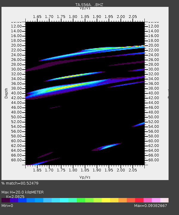
| Estimated Moho Depth: |
20.0 km |
| Estimated Crust Vp/Vs: |
2.08 |
| Assumed Crust Vp: |
6.419 km/s |
| Estimated Crust Vs: |
3.082 km/s |
| Estimated Crust Poisson's Ratio: |
0.35 |
|
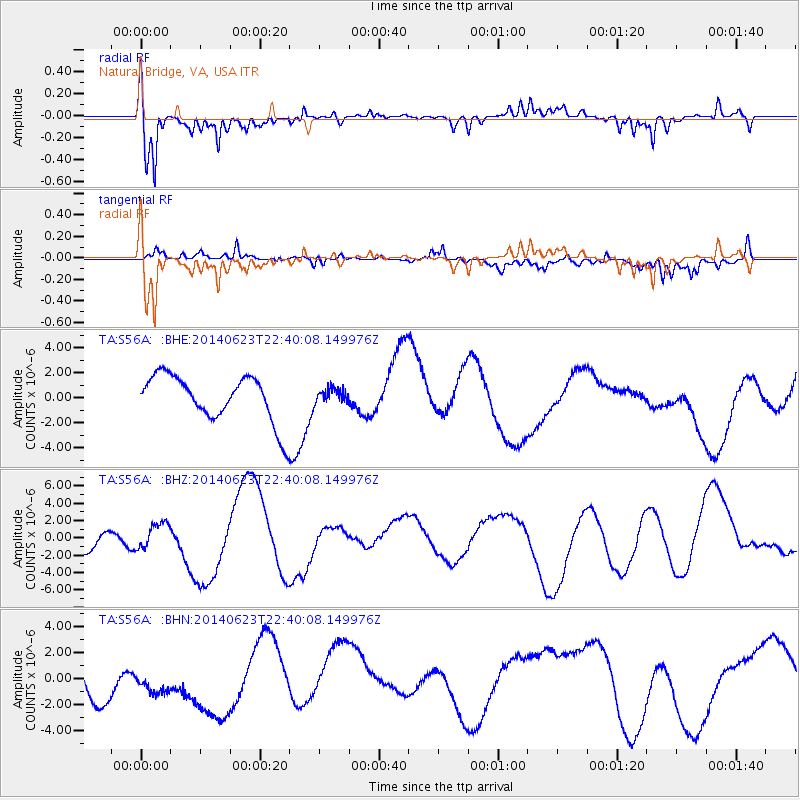
| Radial Match: |
80.52479 % |
| Radial Bump: |
400 |
| Transverse Match: |
55.806133 % |
| Transverse Bump: |
400 |
| SOD ConfigId: |
739768 |
| Insert Time: |
2014-07-08 00:35:21.029 +0000 |
| GWidth: |
2.5 |
| Max Bumps: |
400 |
| Tol: |
0.001 |
|
Signal To Noise
| Channel | StoN | STA | LTA |
| TA:S56A: :BHZ:20140623T22:40:08.149976Z | 0.58355486 | 1.5015344E-6 | 2.5730817E-6 |
| TA:S56A: :BHN:20140623T22:40:08.149976Z | 0.72257924 | 1.3944093E-6 | 1.9297665E-6 |
| TA:S56A: :BHE:20140623T22:40:08.149976Z | 0.31132454 | 5.6837035E-7 | 1.8256522E-6 |
| Arrivals |
| Ps | 3.5 SECOND |
| PpPs | 9.3 SECOND |
| PsPs/PpSs | 13 SECOND |


