You are here: Home > Network List > US - United States National Seismic Network Stations List
> Station DUG Dugway, Tooele County, Utah, USA > Earthquake Result Viewer
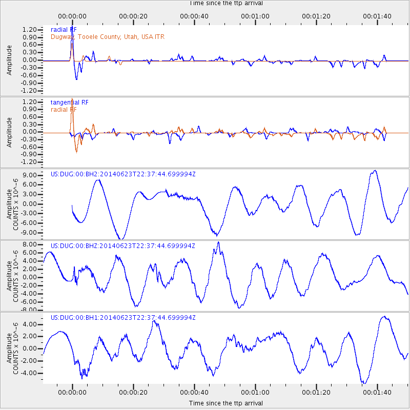
DUG Dugway, Tooele County, Utah, USA - Earthquake Result Viewer
*The percent match for this event was below the threshold and hence no stack was calculated.
| Earthquake location: |
Rat Islands, Aleutian Islands |
| Earthquake latitude/longitude: |
52.0/178.6 |
| Earthquake time(UTC): |
2014/06/23 (174) 22:29:51 GMT |
| Earthquake Depth: |
103 km |
| Earthquake Magnitude: |
5.9 MB |
| Earthquake Catalog/Contributor: |
NEIC PDE/NEIC COMCAT |
|
| Network: |
US United States National Seismic Network |
| Station: |
DUG Dugway, Tooele County, Utah, USA |
| Lat/Lon: |
40.19 N/112.81 W |
| Elevation: |
1477 m |
|
| Distance: |
47.3 deg |
| Az: |
75.95 deg |
| Baz: |
308.4 deg |
| Ray Param: |
$rayparam |
*The percent match for this event was below the threshold and hence was not used in the summary stack. |
|
| Radial Match: |
65.93457 % |
| Radial Bump: |
400 |
| Transverse Match: |
64.50906 % |
| Transverse Bump: |
278 |
| SOD ConfigId: |
739768 |
| Insert Time: |
2014-07-08 00:37:11.814 +0000 |
| GWidth: |
2.5 |
| Max Bumps: |
400 |
| Tol: |
0.001 |
|
Signal To Noise
| Channel | StoN | STA | LTA |
| US:DUG:00:BHZ:20140623T22:37:44.699994Z | 0.55673254 | 2.0300054E-6 | 3.6462845E-6 |
| US:DUG:00:BH1:20140623T22:37:44.699994Z | 0.98224694 | 3.0541094E-6 | 3.109309E-6 |
| US:DUG:00:BH2:20140623T22:37:44.699994Z | 0.8786822 | 4.7738536E-6 | 5.4329694E-6 |
| Arrivals |
| Ps | |
| PpPs | |
| PsPs/PpSs | |


