You are here: Home > Network List > II - Global Seismograph Network (GSN - IRIS/IDA) Stations List
> Station WRAB Tennant Creek, NT, Australia > Earthquake Result Viewer
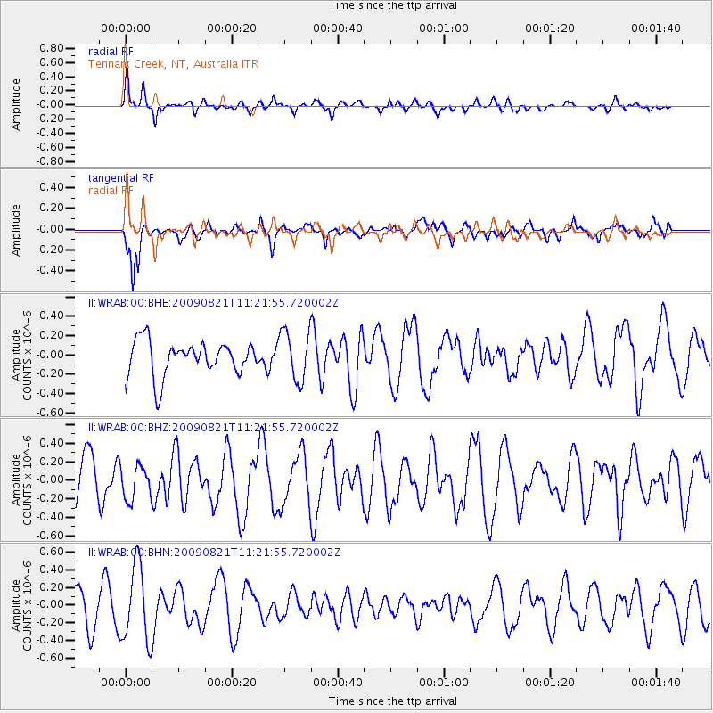
WRAB Tennant Creek, NT, Australia - Earthquake Result Viewer
*The percent match for this event was below the threshold and hence no stack was calculated.
| Earthquake location: |
Southeast Of Loyalty Islands |
| Earthquake latitude/longitude: |
-22.5/171.2 |
| Earthquake time(UTC): |
2009/08/21 (233) 11:15:39 GMT |
| Earthquake Depth: |
10 km |
| Earthquake Magnitude: |
5.7 MW, 5.2 MS, 5.2 MB, 5.6 MW |
| Earthquake Catalog/Contributor: |
WHDF/NEIC |
|
| Network: |
II Global Seismograph Network (GSN - IRIS/IDA) |
| Station: |
WRAB Tennant Creek, NT, Australia |
| Lat/Lon: |
19.93 S/134.36 E |
| Elevation: |
366 m |
|
| Distance: |
34.4 deg |
| Az: |
267.311 deg |
| Baz: |
101.008 deg |
| Ray Param: |
$rayparam |
*The percent match for this event was below the threshold and hence was not used in the summary stack. |
|
| Radial Match: |
51.590015 % |
| Radial Bump: |
400 |
| Transverse Match: |
65.63646 % |
| Transverse Bump: |
372 |
| SOD ConfigId: |
2622 |
| Insert Time: |
2010-03-01 23:29:08.878 +0000 |
| GWidth: |
2.5 |
| Max Bumps: |
400 |
| Tol: |
0.001 |
|
Signal To Noise
| Channel | StoN | STA | LTA |
| II:WRAB:00:BHZ:20090821T11:21:55.720002Z | 0.7662307 | 1.7768993E-7 | 2.3190134E-7 |
| II:WRAB:00:BHN:20090821T11:21:55.720002Z | 2.0801475 | 4.3680987E-7 | 2.0998985E-7 |
| II:WRAB:00:BHE:20090821T11:21:55.720002Z | 1.452274 | 2.5859836E-7 | 1.7806445E-7 |
| Arrivals |
| Ps | |
| PpPs | |
| PsPs/PpSs | |


