You are here: Home > Network List > II - Global Seismograph Network (GSN - IRIS/IDA) Stations List
> Station WRAB Tennant Creek, NT, Australia > Earthquake Result Viewer
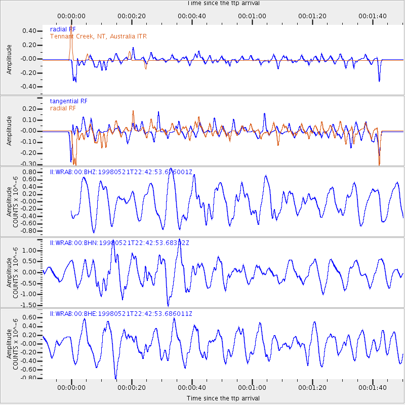
WRAB Tennant Creek, NT, Australia - Earthquake Result Viewer
*The percent match for this event was below the threshold and hence no stack was calculated.
| Earthquake location: |
Prince Edward Islands Region |
| Earthquake latitude/longitude: |
-43.4/41.4 |
| Earthquake time(UTC): |
1998/05/21 (141) 22:31:22 GMT |
| Earthquake Depth: |
10 km |
| Earthquake Magnitude: |
5.8 MS, 5.4 MB, 6.3 UNKNOWN, 6.2 MW |
| Earthquake Catalog/Contributor: |
WHDF/NEIC |
|
| Network: |
II Global Seismograph Network (GSN - IRIS/IDA) |
| Station: |
WRAB Tennant Creek, NT, Australia |
| Lat/Lon: |
19.93 S/134.36 E |
| Elevation: |
366 m |
|
| Distance: |
78.7 deg |
| Az: |
106.619 deg |
| Baz: |
227.933 deg |
| Ray Param: |
$rayparam |
*The percent match for this event was below the threshold and hence was not used in the summary stack. |
|
| Radial Match: |
67.02397 % |
| Radial Bump: |
400 |
| Transverse Match: |
48.4147 % |
| Transverse Bump: |
400 |
| SOD ConfigId: |
4480 |
| Insert Time: |
2010-03-01 23:29:17.457 +0000 |
| GWidth: |
2.5 |
| Max Bumps: |
400 |
| Tol: |
0.001 |
|
Signal To Noise
| Channel | StoN | STA | LTA |
| II:WRAB:00:BHN:19980521T22:42:53.68302Z | 2.2683177 | 4.5990214E-7 | 2.0275031E-7 |
| II:WRAB:00:BHE:19980521T22:42:53.686011Z | 1.9659699 | 3.4469252E-7 | 1.753295E-7 |
| II:WRAB:00:BHZ:19980521T22:42:53.676001Z | 1.649993 | 6.2412704E-7 | 3.7826044E-7 |
| Arrivals |
| Ps | |
| PpPs | |
| PsPs/PpSs | |


