You are here: Home > Network List > II - Global Seismograph Network (GSN - IRIS/IDA) Stations List
> Station WRAB Tennant Creek, NT, Australia > Earthquake Result Viewer
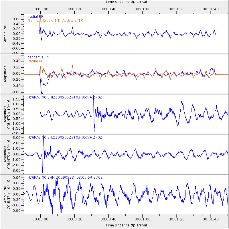
WRAB Tennant Creek, NT, Australia - Earthquake Result Viewer
*The percent match for this event was below the threshold and hence no stack was calculated.
| Earthquake location: |
South Of Fiji Islands |
| Earthquake latitude/longitude: |
-24.4/178.8 |
| Earthquake time(UTC): |
2009/05/23 (143) 02:59:28 GMT |
| Earthquake Depth: |
566 km |
| Earthquake Magnitude: |
5.5 MW, 5.1 MB |
| Earthquake Catalog/Contributor: |
WHDF/NEIC |
|
| Network: |
II Global Seismograph Network (GSN - IRIS/IDA) |
| Station: |
WRAB Tennant Creek, NT, Australia |
| Lat/Lon: |
19.93 S/134.36 E |
| Elevation: |
366 m |
|
| Distance: |
41.3 deg |
| Az: |
267.09 deg |
| Baz: |
104.541 deg |
| Ray Param: |
$rayparam |
*The percent match for this event was below the threshold and hence was not used in the summary stack. |
|
| Radial Match: |
72.10134 % |
| Radial Bump: |
400 |
| Transverse Match: |
72.799164 % |
| Transverse Bump: |
400 |
| SOD ConfigId: |
2648 |
| Insert Time: |
2010-03-01 23:29:20.195 +0000 |
| GWidth: |
2.5 |
| Max Bumps: |
400 |
| Tol: |
0.001 |
|
Signal To Noise
| Channel | StoN | STA | LTA |
| II:WRAB:00:BHZ:20090523T03:05:54.270Z | 4.996935 | 1.1861771E-6 | 2.3738095E-7 |
| II:WRAB:00:BHN:20090523T03:05:54.270Z | 0.9327403 | 3.0623812E-7 | 3.2832088E-7 |
| II:WRAB:00:BHE:20090523T03:05:54.270Z | 2.7381623 | 6.0959326E-7 | 2.2262863E-7 |
| Arrivals |
| Ps | |
| PpPs | |
| PsPs/PpSs | |


