You are here: Home > Network List > II - Global Seismograph Network (GSN - IRIS/IDA) Stations List
> Station WRAB Tennant Creek, NT, Australia > Earthquake Result Viewer
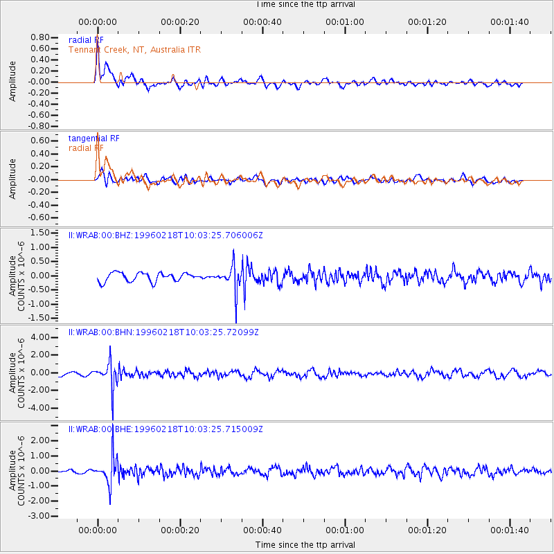
WRAB Tennant Creek, NT, Australia - Earthquake Result Viewer
*The percent match for this event was below the threshold and hence no stack was calculated.
| Earthquake location: |
Mindoro, Philippines |
| Earthquake latitude/longitude: |
13.9/120.8 |
| Earthquake time(UTC): |
1996/02/18 (049) 09:57:16 GMT |
| Earthquake Depth: |
242 km |
| Earthquake Magnitude: |
5.6 UNKNOWN, 5.4 MB |
| Earthquake Catalog/Contributor: |
WHDF/NEIC |
|
| Network: |
II Global Seismograph Network (GSN - IRIS/IDA) |
| Station: |
WRAB Tennant Creek, NT, Australia |
| Lat/Lon: |
19.93 S/134.36 E |
| Elevation: |
366 m |
|
| Distance: |
36.2 deg |
| Az: |
158.003 deg |
| Baz: |
337.255 deg |
| Ray Param: |
$rayparam |
*The percent match for this event was below the threshold and hence was not used in the summary stack. |
|
| Radial Match: |
75.94527 % |
| Radial Bump: |
400 |
| Transverse Match: |
46.8488 % |
| Transverse Bump: |
400 |
| SOD ConfigId: |
4480 |
| Insert Time: |
2010-03-01 23:29:27.739 +0000 |
| GWidth: |
2.5 |
| Max Bumps: |
400 |
| Tol: |
0.001 |
|
Signal To Noise
| Channel | StoN | STA | LTA |
| II:WRAB:00:BHN:19960218T10:03:25.72099Z | 6.7152233 | 1.3912772E-6 | 2.0718258E-7 |
| II:WRAB:00:BHE:19960218T10:03:25.715009Z | 7.2482753 | 9.030266E-7 | 1.2458503E-7 |
| II:WRAB:00:BHZ:19960218T10:03:25.706006Z | 2.8490038 | 4.33958E-7 | 1.523192E-7 |
| Arrivals |
| Ps | |
| PpPs | |
| PsPs/PpSs | |


