You are here: Home > Network List > II - Global Seismograph Network (GSN - IRIS/IDA) Stations List
> Station WRAB Tennant Creek, NT, Australia > Earthquake Result Viewer
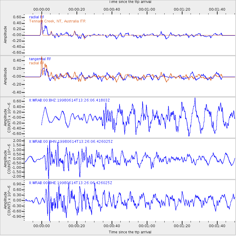
WRAB Tennant Creek, NT, Australia - Earthquake Result Viewer
*The percent match for this event was below the threshold and hence no stack was calculated.
| Earthquake location: |
Near East Coast Of Honshu, Japan |
| Earthquake latitude/longitude: |
35.4/140.5 |
| Earthquake time(UTC): |
1998/06/14 (165) 13:17:08 GMT |
| Earthquake Depth: |
45 km |
| Earthquake Magnitude: |
5.5 MB, 5.3 MS, 5.8 UNKNOWN, 5.8 MW |
| Earthquake Catalog/Contributor: |
WHDF/NEIC |
|
| Network: |
II Global Seismograph Network (GSN - IRIS/IDA) |
| Station: |
WRAB Tennant Creek, NT, Australia |
| Lat/Lon: |
19.93 S/134.36 E |
| Elevation: |
366 m |
|
| Distance: |
55.3 deg |
| Az: |
187.052 deg |
| Baz: |
6.122 deg |
| Ray Param: |
$rayparam |
*The percent match for this event was below the threshold and hence was not used in the summary stack. |
|
| Radial Match: |
66.980225 % |
| Radial Bump: |
400 |
| Transverse Match: |
67.80254 % |
| Transverse Bump: |
400 |
| SOD ConfigId: |
4480 |
| Insert Time: |
2010-03-01 23:29:34.160 +0000 |
| GWidth: |
2.5 |
| Max Bumps: |
400 |
| Tol: |
0.001 |
|
Signal To Noise
| Channel | StoN | STA | LTA |
| II:WRAB:00:BHN:19980614T13:26:06.426025Z | 2.9309564 | 8.7103643E-7 | 2.9718507E-7 |
| II:WRAB:00:BHE:19980614T13:26:06.426025Z | 1.5904647 | 4.4268026E-7 | 2.783339E-7 |
| II:WRAB:00:BHZ:19980614T13:26:06.41803Z | 0.5571341 | 8.64885E-8 | 1.5523821E-7 |
| Arrivals |
| Ps | |
| PpPs | |
| PsPs/PpSs | |


