You are here: Home > Network List > II - Global Seismograph Network (GSN - IRIS/IDA) Stations List
> Station WRAB Tennant Creek, NT, Australia > Earthquake Result Viewer
WRAB Tennant Creek, NT, Australia - Earthquake Result Viewer
*The percent match for this event was below the threshold and hence no stack was calculated.
| Earthquake location: |
Southeast Of Loyalty Islands |
| Earthquake latitude/longitude: |
-21.6/169.8 |
| Earthquake time(UTC): |
1998/07/31 (212) 12:40:59 GMT |
| Earthquake Depth: |
33 km |
| Earthquake Magnitude: |
5.9 MS, 5.4 MB, 6.1 UNKNOWN, 6.0 MW |
| Earthquake Catalog/Contributor: |
WHDF/NEIC |
|
| Network: |
II Global Seismograph Network (GSN - IRIS/IDA) |
| Station: |
WRAB Tennant Creek, NT, Australia |
| Lat/Lon: |
19.93 S/134.36 E |
| Elevation: |
366 m |
|
| Distance: |
33.2 deg |
| Az: |
266.359 deg |
| Baz: |
99.225 deg |
| Ray Param: |
$rayparam |
*The percent match for this event was below the threshold and hence was not used in the summary stack. |
|
| Radial Match: |
64.042946 % |
| Radial Bump: |
400 |
| Transverse Match: |
64.827545 % |
| Transverse Bump: |
400 |
| SOD ConfigId: |
4480 |
| Insert Time: |
2010-03-01 23:29:53.454 +0000 |
| GWidth: |
2.5 |
| Max Bumps: |
400 |
| Tol: |
0.001 |
|
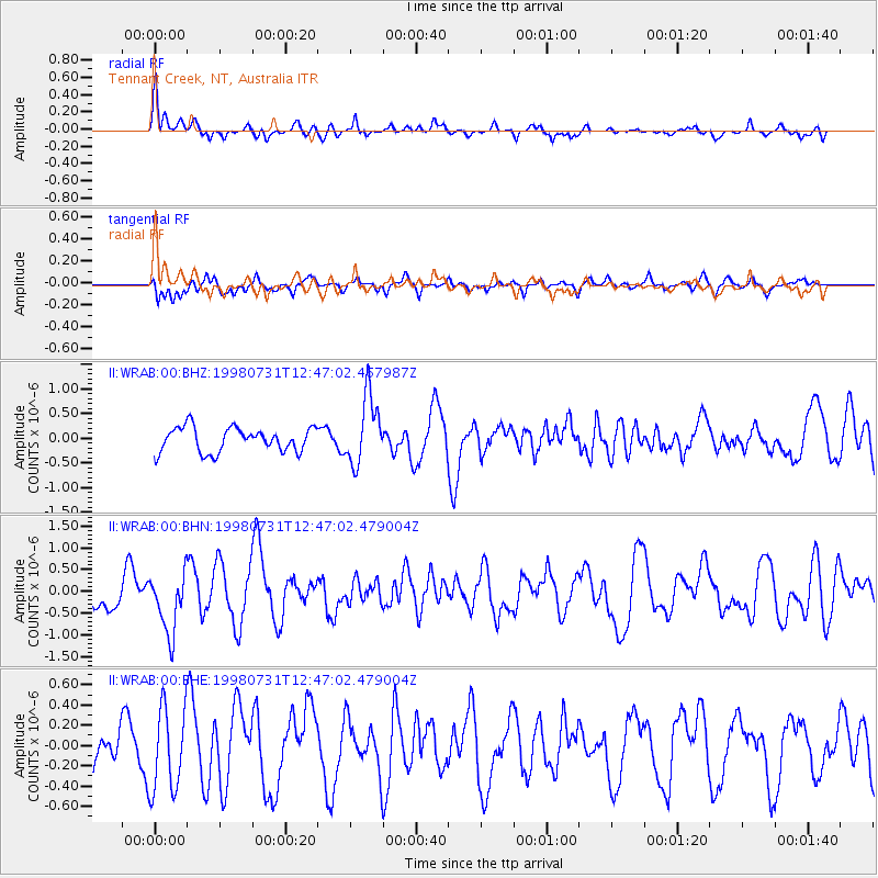
Signal To Noise
| Channel | StoN | STA | LTA |
| II:WRAB:00:BHN:19980731T12:47:02.479004Z | 2.2651536 | 6.8678304E-7 | 3.0319492E-7 |
| II:WRAB:00:BHE:19980731T12:47:02.479004Z | 1.4732566 | 4.1621888E-7 | 2.8251623E-7 |
| II:WRAB:00:BHZ:19980731T12:47:02.467987Z | 2.765713 | 6.856305E-7 | 2.479037E-7 |
| Arrivals |
| Ps | |
| PpPs | |
| PsPs/PpSs | |


