You are here: Home > Network List > TA - USArray Transportable Network (new EarthScope stations) Stations List
> Station D62A Allapoint, Allagash, ME, USA > Earthquake Result Viewer
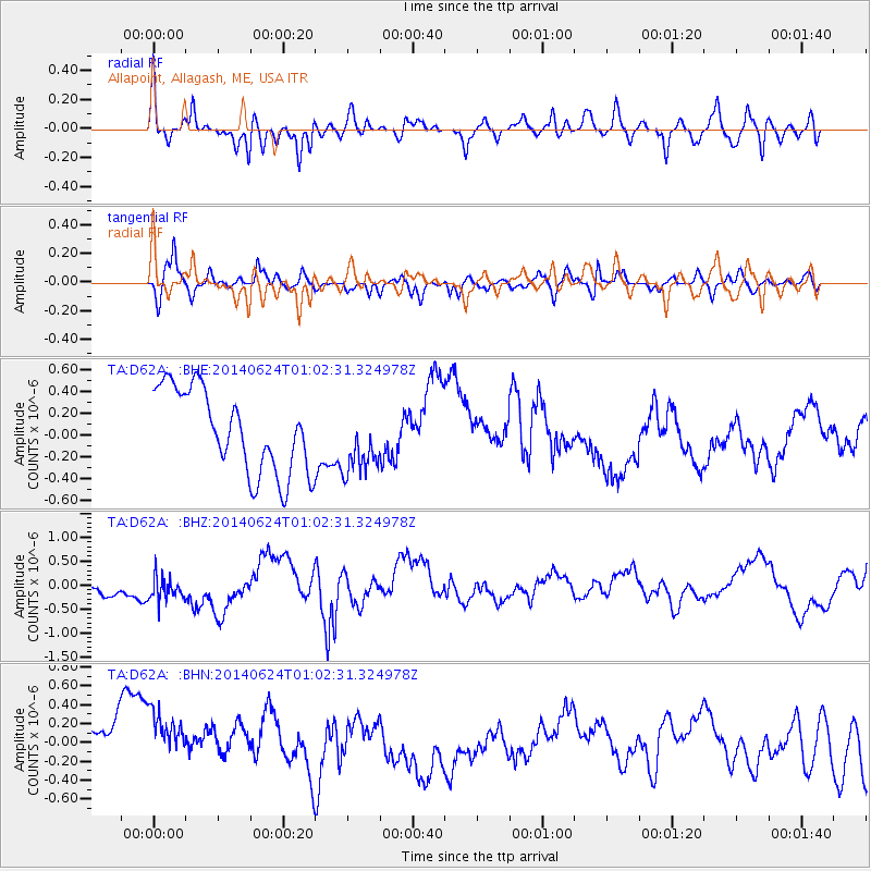
D62A Allapoint, Allagash, ME, USA - Earthquake Result Viewer
*The percent match for this event was below the threshold and hence no stack was calculated.
| Earthquake location: |
Rat Islands, Aleutian Islands |
| Earthquake latitude/longitude: |
52.0/178.4 |
| Earthquake time(UTC): |
2014/06/24 (175) 00:52:28 GMT |
| Earthquake Depth: |
103 km |
| Earthquake Magnitude: |
5.7 MB |
| Earthquake Catalog/Contributor: |
NEIC PDE/NEIC COMCAT |
|
| Network: |
TA USArray Transportable Network (new EarthScope stations) |
| Station: |
D62A Allapoint, Allagash, ME, USA |
| Lat/Lon: |
47.08 N/69.05 W |
| Elevation: |
189 m |
|
| Distance: |
65.7 deg |
| Az: |
43.852 deg |
| Baz: |
321.183 deg |
| Ray Param: |
$rayparam |
*The percent match for this event was below the threshold and hence was not used in the summary stack. |
|
| Radial Match: |
65.471306 % |
| Radial Bump: |
400 |
| Transverse Match: |
61.395874 % |
| Transverse Bump: |
400 |
| SOD ConfigId: |
739768 |
| Insert Time: |
2014-07-08 01:37:35.288 +0000 |
| GWidth: |
2.5 |
| Max Bumps: |
400 |
| Tol: |
0.001 |
|
Signal To Noise
| Channel | StoN | STA | LTA |
| TA:D62A: :BHZ:20140624T01:02:31.324978Z | 1.3594012 | 4.0512424E-7 | 2.980167E-7 |
| TA:D62A: :BHN:20140624T01:02:31.324978Z | 1.5552605 | 4.342502E-7 | 2.7921382E-7 |
| TA:D62A: :BHE:20140624T01:02:31.324978Z | 0.7918005 | 3.010396E-7 | 3.8019627E-7 |
| Arrivals |
| Ps | |
| PpPs | |
| PsPs/PpSs | |


