You are here: Home > Network List > II - Global Seismograph Network (GSN - IRIS/IDA) Stations List
> Station WRAB Tennant Creek, NT, Australia > Earthquake Result Viewer
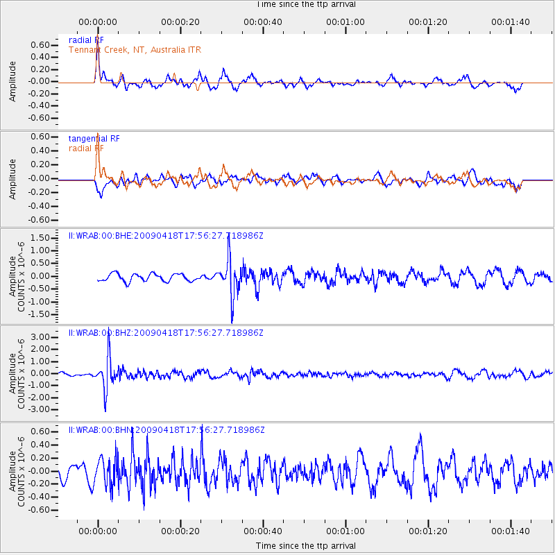
WRAB Tennant Creek, NT, Australia - Earthquake Result Viewer
*The percent match for this event was below the threshold and hence no stack was calculated.
| Earthquake location: |
Fiji Islands Region |
| Earthquake latitude/longitude: |
-20.6/-178.5 |
| Earthquake time(UTC): |
2009/04/18 (108) 17:49:39 GMT |
| Earthquake Depth: |
566 km |
| Earthquake Magnitude: |
5.7 MW, 5.0 MB, 5.7 MW |
| Earthquake Catalog/Contributor: |
WHDF/NEIC |
|
| Network: |
II Global Seismograph Network (GSN - IRIS/IDA) |
| Station: |
WRAB Tennant Creek, NT, Australia |
| Lat/Lon: |
19.93 S/134.36 E |
| Elevation: |
366 m |
|
| Distance: |
44.1 deg |
| Az: |
262.275 deg |
| Baz: |
99.375 deg |
| Ray Param: |
$rayparam |
*The percent match for this event was below the threshold and hence was not used in the summary stack. |
|
| Radial Match: |
63.519432 % |
| Radial Bump: |
323 |
| Transverse Match: |
62.16764 % |
| Transverse Bump: |
400 |
| SOD ConfigId: |
2658 |
| Insert Time: |
2010-03-01 23:30:03.382 +0000 |
| GWidth: |
2.5 |
| Max Bumps: |
400 |
| Tol: |
0.001 |
|
Signal To Noise
| Channel | StoN | STA | LTA |
| II:WRAB:00:BHZ:20090418T17:56:27.718986Z | 9.219596 | 1.3229958E-6 | 1.4349824E-7 |
| II:WRAB:00:BHN:20090418T17:56:27.718986Z | 1.3381375 | 2.0624074E-7 | 1.5412522E-7 |
| II:WRAB:00:BHE:20090418T17:56:27.718986Z | 5.118469 | 7.4081805E-7 | 1.447343E-7 |
| Arrivals |
| Ps | |
| PpPs | |
| PsPs/PpSs | |


