You are here: Home > Network List > TA - USArray Transportable Network (new EarthScope stations) Stations List
> Station G59A Clarenceville, QC, USA > Earthquake Result Viewer
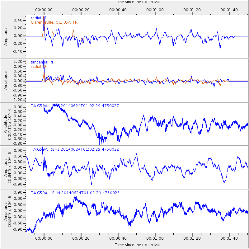
G59A Clarenceville, QC, USA - Earthquake Result Viewer
*The percent match for this event was below the threshold and hence no stack was calculated.
| Earthquake location: |
Rat Islands, Aleutian Islands |
| Earthquake latitude/longitude: |
52.0/178.4 |
| Earthquake time(UTC): |
2014/06/24 (175) 00:52:28 GMT |
| Earthquake Depth: |
103 km |
| Earthquake Magnitude: |
5.7 MB |
| Earthquake Catalog/Contributor: |
NEIC PDE/NEIC COMCAT |
|
| Network: |
TA USArray Transportable Network (new EarthScope stations) |
| Station: |
G59A Clarenceville, QC, USA |
| Lat/Lon: |
45.08 N/73.18 W |
| Elevation: |
36 m |
|
| Distance: |
65.4 deg |
| Az: |
47.687 deg |
| Baz: |
319.805 deg |
| Ray Param: |
$rayparam |
*The percent match for this event was below the threshold and hence was not used in the summary stack. |
|
| Radial Match: |
60.722607 % |
| Radial Bump: |
378 |
| Transverse Match: |
80.685326 % |
| Transverse Bump: |
400 |
| SOD ConfigId: |
739768 |
| Insert Time: |
2014-07-08 01:38:29.964 +0000 |
| GWidth: |
2.5 |
| Max Bumps: |
400 |
| Tol: |
0.001 |
|
Signal To Noise
| Channel | StoN | STA | LTA |
| TA:G59A: :BHZ:20140624T01:02:29.475002Z | 0.72195286 | 3.851851E-7 | 5.335322E-7 |
| TA:G59A: :BHN:20140624T01:02:29.475002Z | 0.47360617 | 5.25041E-7 | 1.1086025E-6 |
| TA:G59A: :BHE:20140624T01:02:29.475002Z | 3.1764321 | 9.858181E-7 | 3.1035393E-7 |
| Arrivals |
| Ps | |
| PpPs | |
| PsPs/PpSs | |


