You are here: Home > Network List > TA - USArray Transportable Network (new EarthScope stations) Stations List
> Station J49A Marlette, MI, USA > Earthquake Result Viewer
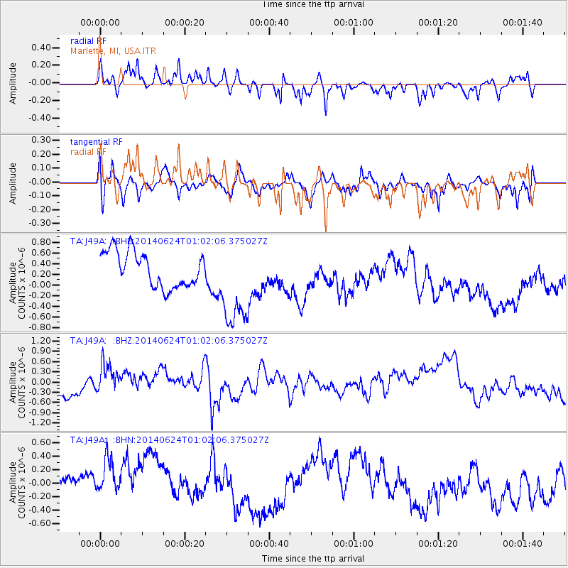
J49A Marlette, MI, USA - Earthquake Result Viewer
*The percent match for this event was below the threshold and hence no stack was calculated.
| Earthquake location: |
Rat Islands, Aleutian Islands |
| Earthquake latitude/longitude: |
52.0/178.4 |
| Earthquake time(UTC): |
2014/06/24 (175) 00:52:28 GMT |
| Earthquake Depth: |
103 km |
| Earthquake Magnitude: |
5.7 MB |
| Earthquake Catalog/Contributor: |
NEIC PDE/NEIC COMCAT |
|
| Network: |
TA USArray Transportable Network (new EarthScope stations) |
| Station: |
J49A Marlette, MI, USA |
| Lat/Lon: |
43.36 N/83.14 W |
| Elevation: |
253 m |
|
| Distance: |
61.9 deg |
| Az: |
54.9 deg |
| Baz: |
316.083 deg |
| Ray Param: |
$rayparam |
*The percent match for this event was below the threshold and hence was not used in the summary stack. |
|
| Radial Match: |
59.05042 % |
| Radial Bump: |
313 |
| Transverse Match: |
67.37413 % |
| Transverse Bump: |
400 |
| SOD ConfigId: |
739768 |
| Insert Time: |
2014-07-08 01:40:13.014 +0000 |
| GWidth: |
2.5 |
| Max Bumps: |
400 |
| Tol: |
0.001 |
|
Signal To Noise
| Channel | StoN | STA | LTA |
| TA:J49A: :BHZ:20140624T01:02:06.375027Z | 1.16075 | 4.4872135E-7 | 3.8657882E-7 |
| TA:J49A: :BHN:20140624T01:02:06.375027Z | 2.2609642 | 4.852901E-7 | 2.1463856E-7 |
| TA:J49A: :BHE:20140624T01:02:06.375027Z | 2.6181884 | 8.6587676E-7 | 3.30716E-7 |
| Arrivals |
| Ps | |
| PpPs | |
| PsPs/PpSs | |


