You are here: Home > Network List > TA - USArray Transportable Network (new EarthScope stations) Stations List
> Station V60A Jim Taylor Road, Stokes, NC, USA > Earthquake Result Viewer
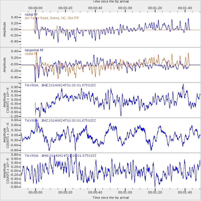
V60A Jim Taylor Road, Stokes, NC, USA - Earthquake Result Viewer
*The percent match for this event was below the threshold and hence no stack was calculated.
| Earthquake location: |
Rat Islands, Aleutian Islands |
| Earthquake latitude/longitude: |
52.0/178.4 |
| Earthquake time(UTC): |
2014/06/24 (175) 00:52:28 GMT |
| Earthquake Depth: |
103 km |
| Earthquake Magnitude: |
5.7 MB |
| Earthquake Catalog/Contributor: |
NEIC PDE/NEIC COMCAT |
|
| Network: |
TA USArray Transportable Network (new EarthScope stations) |
| Station: |
V60A Jim Taylor Road, Stokes, NC, USA |
| Lat/Lon: |
35.76 N/77.26 W |
| Elevation: |
8.0 m |
|
| Distance: |
70.5 deg |
| Az: |
56.696 deg |
| Baz: |
320.548 deg |
| Ray Param: |
$rayparam |
*The percent match for this event was below the threshold and hence was not used in the summary stack. |
|
| Radial Match: |
52.994995 % |
| Radial Bump: |
400 |
| Transverse Match: |
61.20197 % |
| Transverse Bump: |
400 |
| SOD ConfigId: |
739768 |
| Insert Time: |
2014-07-08 01:45:10.783 +0000 |
| GWidth: |
2.5 |
| Max Bumps: |
400 |
| Tol: |
0.001 |
|
Signal To Noise
| Channel | StoN | STA | LTA |
| TA:V60A: :BHZ:20140624T01:03:01.675015Z | 2.083465 | 5.482808E-7 | 2.6315814E-7 |
| TA:V60A: :BHN:20140624T01:03:01.675015Z | 1.3452293 | 3.8078855E-7 | 2.8306593E-7 |
| TA:V60A: :BHE:20140624T01:03:01.675015Z | 1.2061536 | 5.39429E-7 | 4.4723075E-7 |
| Arrivals |
| Ps | |
| PpPs | |
| PsPs/PpSs | |


