You are here: Home > Network List > TA - USArray Transportable Network (new EarthScope stations) Stations List
> Station Z41A Richland Creek Farm, El Dorado, AR, USA > Earthquake Result Viewer
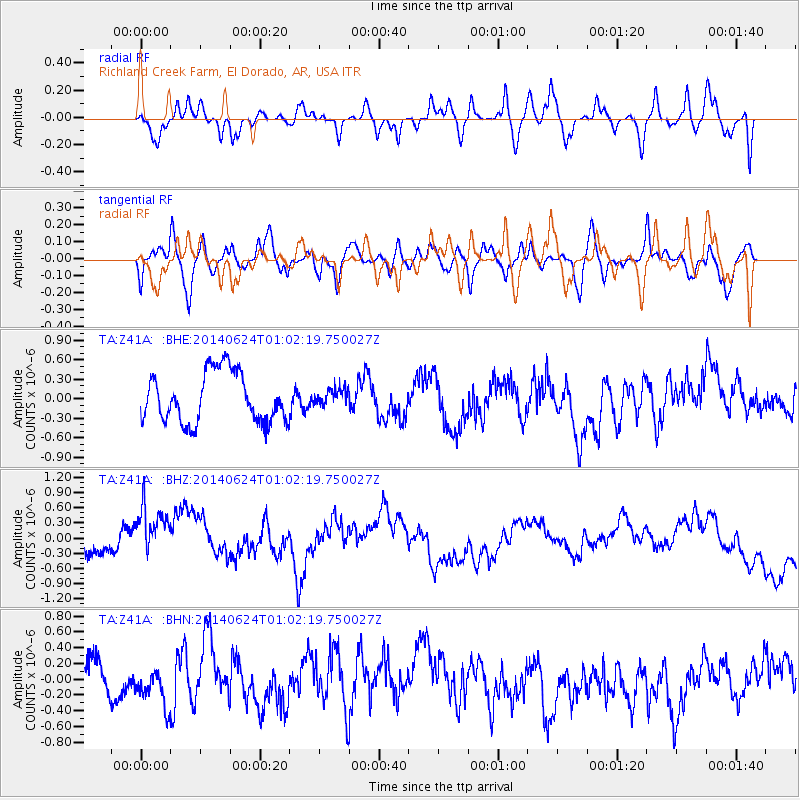
Z41A Richland Creek Farm, El Dorado, AR, USA - Earthquake Result Viewer
*The percent match for this event was below the threshold and hence no stack was calculated.
| Earthquake location: |
Rat Islands, Aleutian Islands |
| Earthquake latitude/longitude: |
52.0/178.4 |
| Earthquake time(UTC): |
2014/06/24 (175) 00:52:28 GMT |
| Earthquake Depth: |
103 km |
| Earthquake Magnitude: |
5.7 MB |
| Earthquake Catalog/Contributor: |
NEIC PDE/NEIC COMCAT |
|
| Network: |
TA USArray Transportable Network (new EarthScope stations) |
| Station: |
Z41A Richland Creek Farm, El Dorado, AR, USA |
| Lat/Lon: |
33.26 N/92.80 W |
| Elevation: |
62 m |
|
| Distance: |
63.9 deg |
| Az: |
68.895 deg |
| Baz: |
316.492 deg |
| Ray Param: |
$rayparam |
*The percent match for this event was below the threshold and hence was not used in the summary stack. |
|
| Radial Match: |
54.265217 % |
| Radial Bump: |
400 |
| Transverse Match: |
49.725502 % |
| Transverse Bump: |
400 |
| SOD ConfigId: |
739768 |
| Insert Time: |
2014-07-08 01:46:06.400 +0000 |
| GWidth: |
2.5 |
| Max Bumps: |
400 |
| Tol: |
0.001 |
|
Signal To Noise
| Channel | StoN | STA | LTA |
| TA:Z41A: :BHZ:20140624T01:02:19.750027Z | 2.2002845 | 6.578994E-7 | 2.9900653E-7 |
| TA:Z41A: :BHN:20140624T01:02:19.750027Z | 0.5408191 | 2.0360233E-7 | 3.7647027E-7 |
| TA:Z41A: :BHE:20140624T01:02:19.750027Z | 0.34518424 | 1.3162993E-7 | 3.8133237E-7 |
| Arrivals |
| Ps | |
| PpPs | |
| PsPs/PpSs | |


