You are here: Home > Network List > II - Global Seismograph Network (GSN - IRIS/IDA) Stations List
> Station WRAB Tennant Creek, NT, Australia > Earthquake Result Viewer
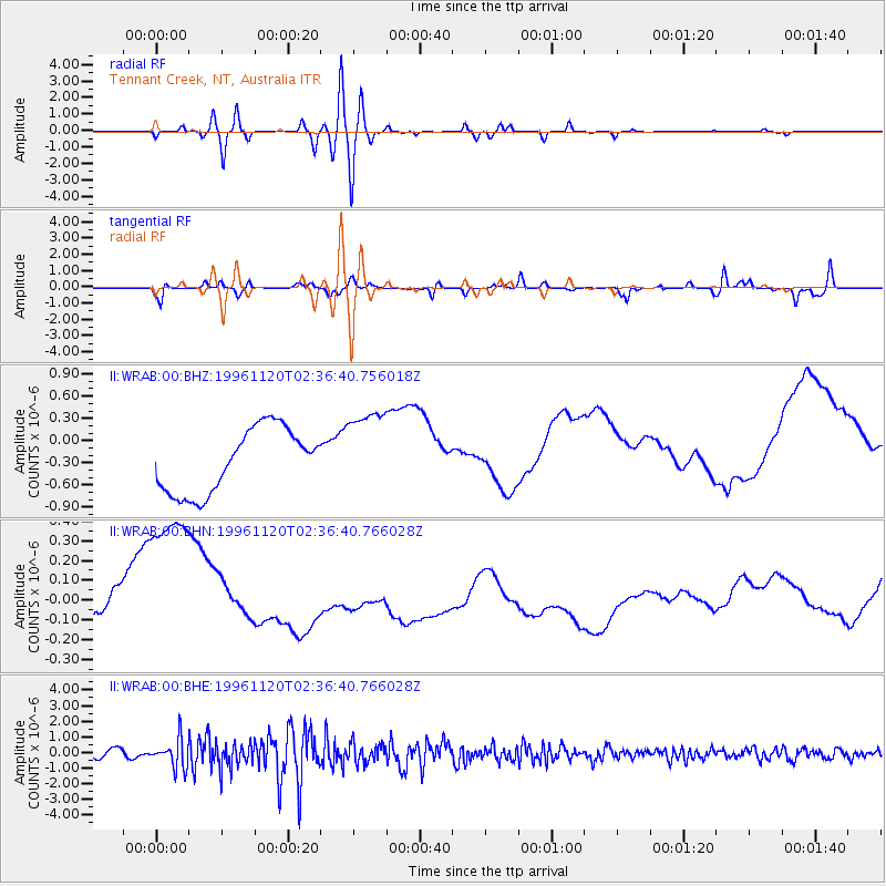
WRAB Tennant Creek, NT, Australia - Earthquake Result Viewer
*The percent match for this event was below the threshold and hence no stack was calculated.
| Earthquake location: |
Off East Coast Of Honshu, Japan |
| Earthquake latitude/longitude: |
34.3/141.1 |
| Earthquake time(UTC): |
1996/11/20 (325) 02:27:47 GMT |
| Earthquake Depth: |
33 km |
| Earthquake Magnitude: |
5.9 MB, 5.7 MS, 6.1 UNKNOWN, 6.1 MW |
| Earthquake Catalog/Contributor: |
WHDF/NEIC |
|
| Network: |
II Global Seismograph Network (GSN - IRIS/IDA) |
| Station: |
WRAB Tennant Creek, NT, Australia |
| Lat/Lon: |
19.93 S/134.36 E |
| Elevation: |
366 m |
|
| Distance: |
54.4 deg |
| Az: |
187.845 deg |
| Baz: |
6.894 deg |
| Ray Param: |
$rayparam |
*The percent match for this event was below the threshold and hence was not used in the summary stack. |
|
| Radial Match: |
17.350462 % |
| Radial Bump: |
400 |
| Transverse Match: |
62.114006 % |
| Transverse Bump: |
400 |
| SOD ConfigId: |
4480 |
| Insert Time: |
2010-03-01 23:30:19.050 +0000 |
| GWidth: |
2.5 |
| Max Bumps: |
400 |
| Tol: |
0.001 |
|
Signal To Noise
| Channel | StoN | STA | LTA |
| II:WRAB:00:BHN:19961120T02:36:40.766028Z | 4.3031178 | 5.180005E-7 | 1.2037795E-7 |
| II:WRAB:00:BHE:19961120T02:36:40.766028Z | 4.6956334 | 9.0852853E-7 | 1.934837E-7 |
| II:WRAB:00:BHZ:19961120T02:36:40.756018Z | 1.3587874 | 5.8383E-7 | 4.2966985E-7 |
| Arrivals |
| Ps | |
| PpPs | |
| PsPs/PpSs | |


