You are here: Home > Network List > US - United States National Seismic Network Stations List
> Station MSO Missoula, Montana, USA > Earthquake Result Viewer
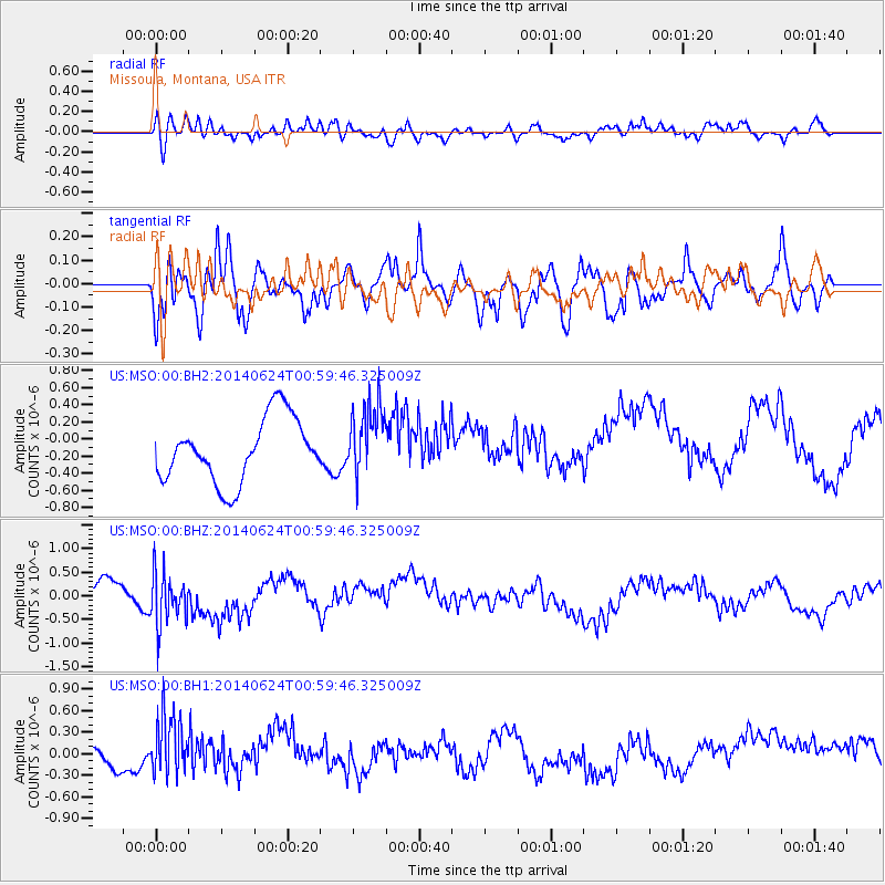
MSO Missoula, Montana, USA - Earthquake Result Viewer
*The percent match for this event was below the threshold and hence no stack was calculated.
| Earthquake location: |
Rat Islands, Aleutian Islands |
| Earthquake latitude/longitude: |
52.0/178.4 |
| Earthquake time(UTC): |
2014/06/24 (175) 00:52:28 GMT |
| Earthquake Depth: |
103 km |
| Earthquake Magnitude: |
5.7 MB |
| Earthquake Catalog/Contributor: |
NEIC PDE/NEIC COMCAT |
|
| Network: |
US United States National Seismic Network |
| Station: |
MSO Missoula, Montana, USA |
| Lat/Lon: |
46.83 N/113.94 W |
| Elevation: |
1264 m |
|
| Distance: |
42.9 deg |
| Az: |
68.966 deg |
| Baz: |
302.802 deg |
| Ray Param: |
$rayparam |
*The percent match for this event was below the threshold and hence was not used in the summary stack. |
|
| Radial Match: |
39.59946 % |
| Radial Bump: |
395 |
| Transverse Match: |
50.750996 % |
| Transverse Bump: |
400 |
| SOD ConfigId: |
739768 |
| Insert Time: |
2014-07-08 01:48:08.628 +0000 |
| GWidth: |
2.5 |
| Max Bumps: |
400 |
| Tol: |
0.001 |
|
Signal To Noise
| Channel | StoN | STA | LTA |
| US:MSO:00:BHZ:20140624T00:59:46.325009Z | 2.4607358 | 5.477272E-7 | 2.2258676E-7 |
| US:MSO:00:BH1:20140624T00:59:46.325009Z | 2.6387656 | 4.4300498E-7 | 1.678834E-7 |
| US:MSO:00:BH2:20140624T00:59:46.325009Z | 1.1226436 | 4.1725818E-7 | 3.7167467E-7 |
| Arrivals |
| Ps | |
| PpPs | |
| PsPs/PpSs | |


