You are here: Home > Network List > II - Global Seismograph Network (GSN - IRIS/IDA) Stations List
> Station WRAB Tennant Creek, NT, Australia > Earthquake Result Viewer
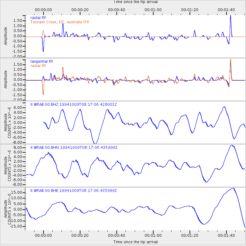
WRAB Tennant Creek, NT, Australia - Earthquake Result Viewer
*The percent match for this event was below the threshold and hence no stack was calculated.
| Earthquake location: |
East Of Kuril Islands |
| Earthquake latitude/longitude: |
43.7/148.0 |
| Earthquake time(UTC): |
1994/10/09 (282) 08:07:04 GMT |
| Earthquake Depth: |
42 km |
| Earthquake Magnitude: |
5.9 MB |
| Earthquake Catalog/Contributor: |
WHDF/NEIC |
|
| Network: |
II Global Seismograph Network (GSN - IRIS/IDA) |
| Station: |
WRAB Tennant Creek, NT, Australia |
| Lat/Lon: |
19.93 S/134.36 E |
| Elevation: |
366 m |
|
| Distance: |
64.5 deg |
| Az: |
194.237 deg |
| Baz: |
10.934 deg |
| Ray Param: |
$rayparam |
*The percent match for this event was below the threshold and hence was not used in the summary stack. |
|
| Radial Match: |
58.585995 % |
| Radial Bump: |
400 |
| Transverse Match: |
56.098846 % |
| Transverse Bump: |
400 |
| SOD ConfigId: |
4480 |
| Insert Time: |
2010-03-01 23:30:26.650 +0000 |
| GWidth: |
2.5 |
| Max Bumps: |
400 |
| Tol: |
0.001 |
|
Signal To Noise
| Channel | StoN | STA | LTA |
| II:WRAB:00:BHN:19941009T08:17:06.435999Z | 2.4564772 | 5.395115E-6 | 2.1962815E-6 |
| II:WRAB:00:BHE:19941009T08:17:06.435999Z | 0.9510403 | 3.7365155E-6 | 3.9288716E-6 |
| II:WRAB:00:BHZ:19941009T08:17:06.428003Z | 1.8585763 | 4.7383396E-6 | 2.549446E-6 |
| Arrivals |
| Ps | |
| PpPs | |
| PsPs/PpSs | |


