You are here: Home > Network List > II - Global Seismograph Network (GSN - IRIS/IDA) Stations List
> Station WRAB Tennant Creek, NT, Australia > Earthquake Result Viewer
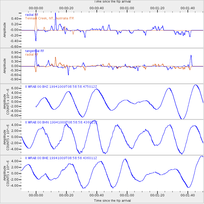
WRAB Tennant Creek, NT, Australia - Earthquake Result Viewer
*The percent match for this event was below the threshold and hence no stack was calculated.
| Earthquake location: |
East Of Kuril Islands |
| Earthquake latitude/longitude: |
43.8/148.1 |
| Earthquake time(UTC): |
1994/10/09 (282) 08:48:54 GMT |
| Earthquake Depth: |
35 km |
| Earthquake Magnitude: |
5.8 MB |
| Earthquake Catalog/Contributor: |
WHDF/NEIC |
|
| Network: |
II Global Seismograph Network (GSN - IRIS/IDA) |
| Station: |
WRAB Tennant Creek, NT, Australia |
| Lat/Lon: |
19.93 S/134.36 E |
| Elevation: |
366 m |
|
| Distance: |
64.7 deg |
| Az: |
194.281 deg |
| Baz: |
10.941 deg |
| Ray Param: |
$rayparam |
*The percent match for this event was below the threshold and hence was not used in the summary stack. |
|
| Radial Match: |
88.25353 % |
| Radial Bump: |
400 |
| Transverse Match: |
58.731876 % |
| Transverse Bump: |
373 |
| SOD ConfigId: |
4480 |
| Insert Time: |
2010-03-01 23:30:27.979 +0000 |
| GWidth: |
2.5 |
| Max Bumps: |
400 |
| Tol: |
0.001 |
|
Signal To Noise
| Channel | StoN | STA | LTA |
| II:WRAB:00:BHN:19941009T08:58:58.436011Z | 0.9168378 | 2.442895E-6 | 2.6644789E-6 |
| II:WRAB:00:BHE:19941009T08:58:58.436011Z | 0.86877275 | 1.2779082E-6 | 1.470935E-6 |
| II:WRAB:00:BHZ:19941009T08:58:58.475012Z | 2.332602 | 5.5429227E-6 | 2.376283E-6 |
| Arrivals |
| Ps | |
| PpPs | |
| PsPs/PpSs | |


