You are here: Home > Network List > II - Global Seismograph Network (GSN - IRIS/IDA) Stations List
> Station WRAB Tennant Creek, NT, Australia > Earthquake Result Viewer
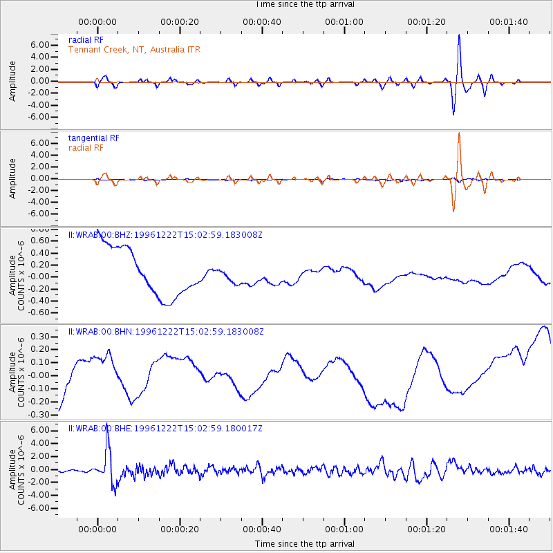
WRAB Tennant Creek, NT, Australia - Earthquake Result Viewer
*The percent match for this event was below the threshold and hence no stack was calculated.
| Earthquake location: |
Eastern Sea Of Japan |
| Earthquake latitude/longitude: |
43.2/138.9 |
| Earthquake time(UTC): |
1996/12/22 (357) 14:53:27 GMT |
| Earthquake Depth: |
227 km |
| Earthquake Magnitude: |
6.0 MB, 6.5 UNKNOWN, 6.5 MW |
| Earthquake Catalog/Contributor: |
WHDF/NEIC |
|
| Network: |
II Global Seismograph Network (GSN - IRIS/IDA) |
| Station: |
WRAB Tennant Creek, NT, Australia |
| Lat/Lon: |
19.93 S/134.36 E |
| Elevation: |
366 m |
|
| Distance: |
63.0 deg |
| Az: |
184.817 deg |
| Baz: |
3.742 deg |
| Ray Param: |
$rayparam |
*The percent match for this event was below the threshold and hence was not used in the summary stack. |
|
| Radial Match: |
39.866577 % |
| Radial Bump: |
400 |
| Transverse Match: |
56.599228 % |
| Transverse Bump: |
396 |
| SOD ConfigId: |
4480 |
| Insert Time: |
2010-03-01 23:30:31.796 +0000 |
| GWidth: |
2.5 |
| Max Bumps: |
400 |
| Tol: |
0.001 |
|
Signal To Noise
| Channel | StoN | STA | LTA |
| II:WRAB:00:BHN:19961222T15:02:59.183008Z | 3.2310526 | 2.435965E-7 | 7.539231E-8 |
| II:WRAB:00:BHE:19961222T15:02:59.180017Z | 20.713942 | 2.8183167E-6 | 1.3605894E-7 |
| II:WRAB:00:BHZ:19961222T15:02:59.183008Z | 0.31921047 | 1.2589778E-7 | 3.9440368E-7 |
| Arrivals |
| Ps | |
| PpPs | |
| PsPs/PpSs | |


