You are here: Home > Network List > II - Global Seismograph Network (GSN - IRIS/IDA) Stations List
> Station WRAB Tennant Creek, NT, Australia > Earthquake Result Viewer
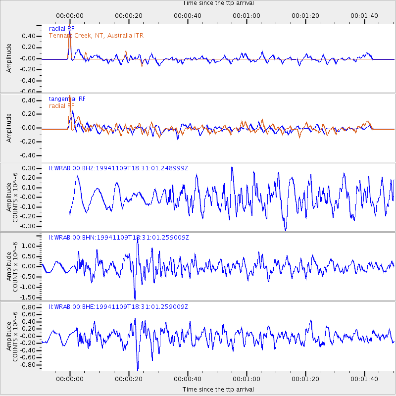
WRAB Tennant Creek, NT, Australia - Earthquake Result Viewer
*The percent match for this event was below the threshold and hence no stack was calculated.
| Earthquake location: |
Kuril Islands |
| Earthquake latitude/longitude: |
43.5/147.2 |
| Earthquake time(UTC): |
1994/11/09 (313) 18:21:03 GMT |
| Earthquake Depth: |
61 km |
| Earthquake Magnitude: |
6.1 MB, 5.8 UNKNOWN, 5.8 MW |
| Earthquake Catalog/Contributor: |
WHDF/NEIC |
|
| Network: |
II Global Seismograph Network (GSN - IRIS/IDA) |
| Station: |
WRAB Tennant Creek, NT, Australia |
| Lat/Lon: |
19.93 S/134.36 E |
| Elevation: |
366 m |
|
| Distance: |
64.2 deg |
| Az: |
193.413 deg |
| Baz: |
10.332 deg |
| Ray Param: |
$rayparam |
*The percent match for this event was below the threshold and hence was not used in the summary stack. |
|
| Radial Match: |
64.73115 % |
| Radial Bump: |
400 |
| Transverse Match: |
64.80535 % |
| Transverse Bump: |
400 |
| SOD ConfigId: |
4480 |
| Insert Time: |
2010-03-01 23:30:34.595 +0000 |
| GWidth: |
2.5 |
| Max Bumps: |
400 |
| Tol: |
0.001 |
|
Signal To Noise
| Channel | StoN | STA | LTA |
| II:WRAB:00:BHN:19941109T18:31:01.259009Z | 1.67176 | 2.5336732E-7 | 1.5155724E-7 |
| II:WRAB:00:BHE:19941109T18:31:01.259009Z | 1.395792 | 1.3538408E-7 | 9.699445E-8 |
| II:WRAB:00:BHZ:19941109T18:31:01.248999Z | 0.5839543 | 5.307842E-8 | 9.089483E-8 |
| Arrivals |
| Ps | |
| PpPs | |
| PsPs/PpSs | |


