You are here: Home > Network List > II - Global Seismograph Network (GSN - IRIS/IDA) Stations List
> Station WRAB Tennant Creek, NT, Australia > Earthquake Result Viewer
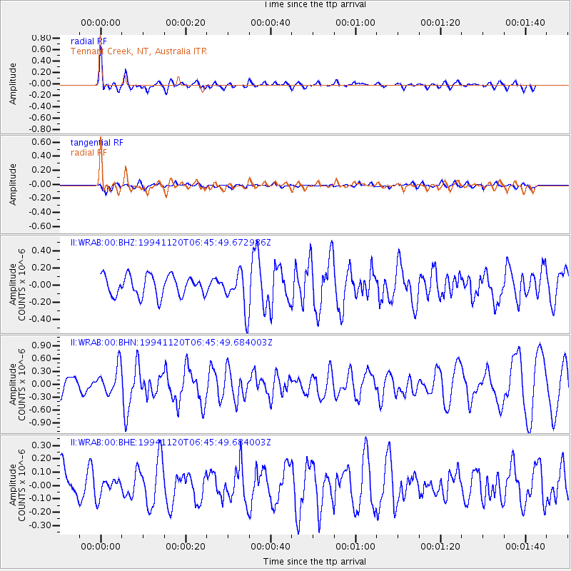
WRAB Tennant Creek, NT, Australia - Earthquake Result Viewer
*The percent match for this event was below the threshold and hence no stack was calculated.
| Earthquake location: |
Vanuatu Islands Region |
| Earthquake latitude/longitude: |
-20.7/172.7 |
| Earthquake time(UTC): |
1994/11/20 (324) 06:39:21 GMT |
| Earthquake Depth: |
24 km |
| Earthquake Magnitude: |
5.5 MB, 5.6 MS, 5.5 UNKNOWN |
| Earthquake Catalog/Contributor: |
WHDF/NEIC |
|
| Network: |
II Global Seismograph Network (GSN - IRIS/IDA) |
| Station: |
WRAB Tennant Creek, NT, Australia |
| Lat/Lon: |
19.93 S/134.36 E |
| Elevation: |
366 m |
|
| Distance: |
35.9 deg |
| Az: |
264.365 deg |
| Baz: |
98.076 deg |
| Ray Param: |
$rayparam |
*The percent match for this event was below the threshold and hence was not used in the summary stack. |
|
| Radial Match: |
78.52465 % |
| Radial Bump: |
400 |
| Transverse Match: |
49.41812 % |
| Transverse Bump: |
400 |
| SOD ConfigId: |
4480 |
| Insert Time: |
2010-03-01 23:30:39.107 +0000 |
| GWidth: |
2.5 |
| Max Bumps: |
400 |
| Tol: |
0.001 |
|
Signal To Noise
| Channel | StoN | STA | LTA |
| II:WRAB:00:BHN:19941120T06:45:49.684003Z | 2.0174081 | 3.3207527E-7 | 1.6460491E-7 |
| II:WRAB:00:BHE:19941120T06:45:49.684003Z | 0.5555458 | 6.518518E-8 | 1.1733539E-7 |
| II:WRAB:00:BHZ:19941120T06:45:49.672986Z | 1.9645503 | 2.3149595E-7 | 1.1783661E-7 |
| Arrivals |
| Ps | |
| PpPs | |
| PsPs/PpSs | |


