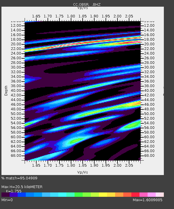
OBSR Observation Rock, Mt. Rainier, WA - Earthquake Result Viewer

Earthquake location: Rat Islands, Aleutian Islands
Earthquake latitude/longitude: 52.3/176.7
Earthquake time(UTC): 2014/06/24 (175) 03:15:36 GMT
Earthquake Depth: 4.0 km
Earthquake Magnitude: 6.3 MWB, 5.7 ML, 6.4 MWC, 6.6 MI
Earthquake Catalog/Contributor: NEIC PDE/NEIC COMCAT
Network: CC Cascade Chain Volcano Monitoring
Station: OBSR Observation Rock, Mt. Rainier, WA
Lat/Lon: 46.90 N/121.82 W
Elevation: 2382 m
Distance: 39.2 deg
Az: 72.571 deg
Baz: 301.202 deg
Ray Param: 0.07516213
Estimated Moho Depth: 20.5 km
Estimated Crust Vp/Vs: 1.75
Assumed Crust Vp: 6.597 km/s
Estimated Crust Vs: 3.759 km/s
Estimated Crust Poisson's Ratio: 0.26
Radial Match: 95.04989 %
Radial Bump: 399
Transverse Match: 69.01281 %
Transverse Bump: 400
SOD ConfigId: 739768
Insert Time: 2014-07-08 03:35:12.841 +0000
GWidth: 2.5
Max Bumps: 400
Tol: 0.001

Signal To Noise

ChannelStoNSTALTA
CC:OBSR: :BHZ:20140624T03:22:34.439995Z3.35561014.481512E-71.3355283E-7
CC:OBSR: :BHN:20140624T03:22:34.439995Z2.32888254.031975E-71.7312917E-7
CC:OBSR: :BHE:20140624T03:22:34.439995Z1.90012472.8368652E-71.492989E-7
Arrivals
Ps2.5 SECOND
PpPs7.9 SECOND
PsPs/PpSs10 SECOND