You are here: Home > Network List > II - Global Seismograph Network (GSN - IRIS/IDA) Stations List
> Station WRAB Tennant Creek, NT, Australia > Earthquake Result Viewer
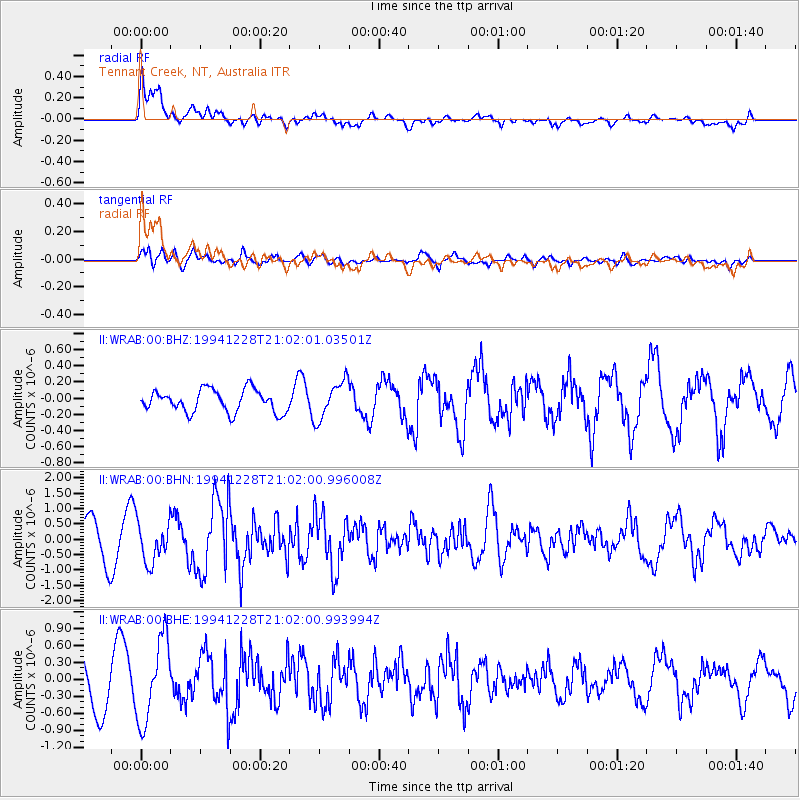
WRAB Tennant Creek, NT, Australia - Earthquake Result Viewer
*The percent match for this event was below the threshold and hence no stack was calculated.
| Earthquake location: |
Near East Coast Of Honshu, Japan |
| Earthquake latitude/longitude: |
40.0/142.7 |
| Earthquake time(UTC): |
1994/12/28 (362) 20:52:28 GMT |
| Earthquake Depth: |
48 km |
| Earthquake Magnitude: |
5.7 MB, 5.8 MS, 5.4 UNKNOWN, 6.2 MW |
| Earthquake Catalog/Contributor: |
WHDF/NEIC |
|
| Network: |
II Global Seismograph Network (GSN - IRIS/IDA) |
| Station: |
WRAB Tennant Creek, NT, Australia |
| Lat/Lon: |
19.93 S/134.36 E |
| Elevation: |
366 m |
|
| Distance: |
60.2 deg |
| Az: |
189.098 deg |
| Baz: |
7.414 deg |
| Ray Param: |
$rayparam |
*The percent match for this event was below the threshold and hence was not used in the summary stack. |
|
| Radial Match: |
71.34974 % |
| Radial Bump: |
400 |
| Transverse Match: |
67.284805 % |
| Transverse Bump: |
400 |
| SOD ConfigId: |
4480 |
| Insert Time: |
2010-03-01 23:30:43.849 +0000 |
| GWidth: |
2.5 |
| Max Bumps: |
400 |
| Tol: |
0.001 |
|
Signal To Noise
| Channel | StoN | STA | LTA |
| II:WRAB:00:BHN:19941228T21:02:00.996008Z | 1.1706821 | 6.512851E-7 | 5.5632967E-7 |
| II:WRAB:00:BHE:19941228T21:02:00.993994Z | 1.8424779 | 7.273619E-7 | 3.9477376E-7 |
| II:WRAB:00:BHZ:19941228T21:02:01.03501Z | 1.7096266 | 2.3670272E-7 | 1.3845288E-7 |
| Arrivals |
| Ps | |
| PpPs | |
| PsPs/PpSs | |


