You are here: Home > Network List > II - Global Seismograph Network (GSN - IRIS/IDA) Stations List
> Station WRAB Tennant Creek, NT, Australia > Earthquake Result Viewer
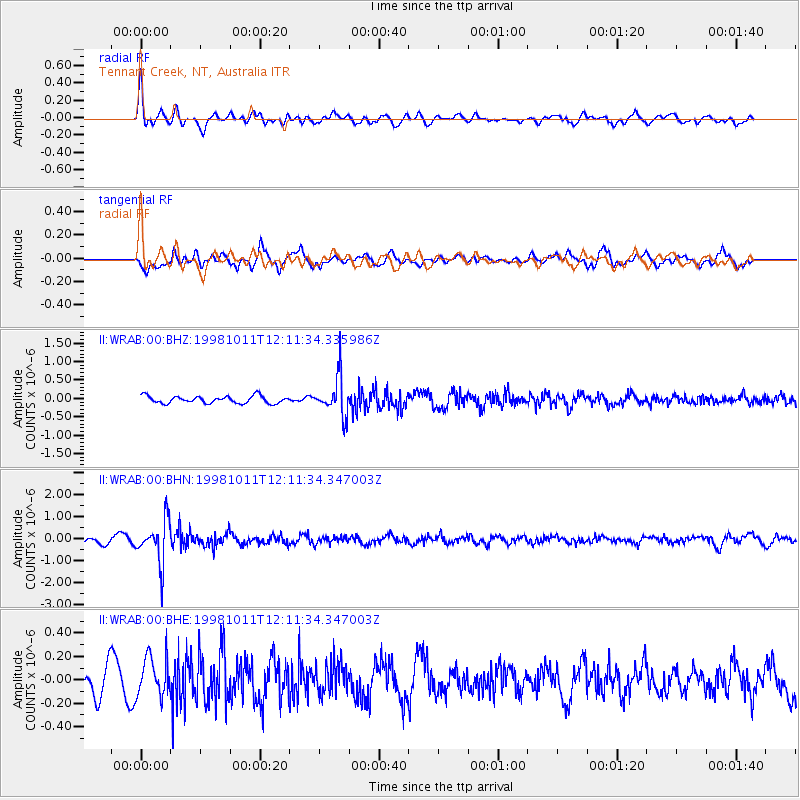
WRAB Tennant Creek, NT, Australia - Earthquake Result Viewer
*The percent match for this event was below the threshold and hence no stack was calculated.
| Earthquake location: |
Fiji Islands Region |
| Earthquake latitude/longitude: |
-21.0/-179.1 |
| Earthquake time(UTC): |
1998/10/11 (284) 12:04:54 GMT |
| Earthquake Depth: |
624 km |
| Earthquake Magnitude: |
5.9 UNKNOWN, 5.4 MB, 5.9 MW |
| Earthquake Catalog/Contributor: |
WHDF/NEIC |
|
| Network: |
II Global Seismograph Network (GSN - IRIS/IDA) |
| Station: |
WRAB Tennant Creek, NT, Australia |
| Lat/Lon: |
19.93 S/134.36 E |
| Elevation: |
366 m |
|
| Distance: |
43.5 deg |
| Az: |
262.857 deg |
| Baz: |
99.873 deg |
| Ray Param: |
$rayparam |
*The percent match for this event was below the threshold and hence was not used in the summary stack. |
|
| Radial Match: |
71.20482 % |
| Radial Bump: |
400 |
| Transverse Match: |
63.03817 % |
| Transverse Bump: |
400 |
| SOD ConfigId: |
4480 |
| Insert Time: |
2010-03-01 23:30:45.911 +0000 |
| GWidth: |
2.5 |
| Max Bumps: |
400 |
| Tol: |
0.001 |
|
Signal To Noise
| Channel | StoN | STA | LTA |
| II:WRAB:00:BHN:19981011T12:11:34.347003Z | 6.5576844 | 9.592143E-7 | 1.4627331E-7 |
| II:WRAB:00:BHE:19981011T12:11:34.347003Z | 1.978536 | 1.667622E-7 | 8.428565E-8 |
| II:WRAB:00:BHZ:19981011T12:11:34.335986Z | 5.296467 | 5.219931E-7 | 9.855496E-8 |
| Arrivals |
| Ps | |
| PpPs | |
| PsPs/PpSs | |


