You are here: Home > Network List > CO - South Carolina Seismic Network Stations List
> Station PAULI Pauline, SC, USA > Earthquake Result Viewer
PAULI Pauline, SC, USA - Earthquake Result Viewer
| Earthquake location: |
Rat Islands, Aleutian Islands |
| Earthquake latitude/longitude: |
52.3/176.7 |
| Earthquake time(UTC): |
2014/06/24 (175) 03:15:36 GMT |
| Earthquake Depth: |
4.0 km |
| Earthquake Magnitude: |
6.3 MWB, 5.7 ML, 6.4 MWC, 6.6 MI |
| Earthquake Catalog/Contributor: |
NEIC PDE/NEIC COMCAT |
|
| Network: |
CO South Carolina Seismic Network |
| Station: |
PAULI Pauline, SC, USA |
| Lat/Lon: |
34.82 N/81.81 W |
| Elevation: |
179 m |
|
| Distance: |
69.6 deg |
| Az: |
59.314 deg |
| Baz: |
320.015 deg |
| Ray Param: |
0.055518858 |
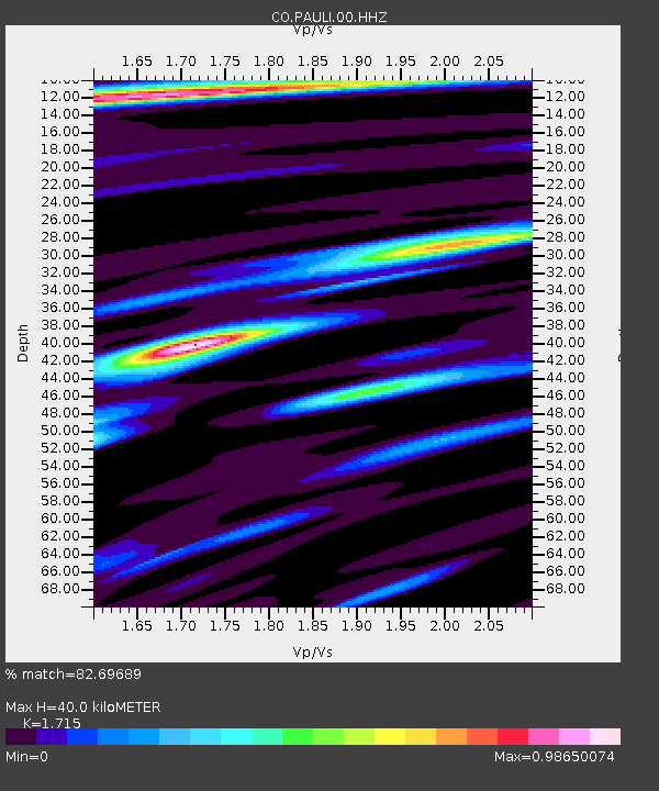
| Estimated Moho Depth: |
40.0 km |
| Estimated Crust Vp/Vs: |
1.72 |
| Assumed Crust Vp: |
6.419 km/s |
| Estimated Crust Vs: |
3.743 km/s |
| Estimated Crust Poisson's Ratio: |
0.24 |
|
| Radial Match: |
82.69689 % |
| Radial Bump: |
400 |
| Transverse Match: |
54.305786 % |
| Transverse Bump: |
400 |
| SOD ConfigId: |
739768 |
| Insert Time: |
2014-07-08 03:40:43.583 +0000 |
| GWidth: |
2.5 |
| Max Bumps: |
400 |
| Tol: |
0.001 |
|

Signal To Noise
| Channel | StoN | STA | LTA |
| CO:PAULI:00:HHZ:20140624T03:26:15.83001Z | 4.6933756 | 6.362887E-7 | 1.3557165E-7 |
| CO:PAULI:00:HHN:20140624T03:26:15.83001Z | 2.6854482 | 2.1327385E-7 | 7.941834E-8 |
| CO:PAULI:00:HHE:20140624T03:26:15.83001Z | 1.6844131 | 1.967334E-7 | 1.1679641E-7 |
| Arrivals |
| Ps | 4.6 SECOND |
| PpPs | 16 SECOND |
| PsPs/PpSs | 21 SECOND |


