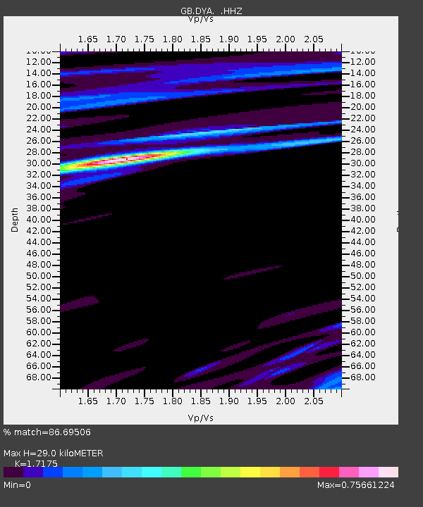
DYA YADSWORTHY, ENGLAND - Earthquake Result Viewer

Earthquake location: Rat Islands, Aleutian Islands
Earthquake latitude/longitude: 52.3/176.7
Earthquake time(UTC): 2014/06/24 (175) 03:15:36 GMT
Earthquake Depth: 4.0 km
Earthquake Magnitude: 6.3 MWB, 5.7 ML, 6.4 MWC, 6.6 MI
Earthquake Catalog/Contributor: NEIC PDE/NEIC COMCAT
Network: GB Great Britain Seismograph Network
Station: DYA YADSWORTHY, ENGLAND
Lat/Lon: 50.44 N/3.93 W
Elevation: 292 m
Distance: 77.7 deg
Az: 0.423 deg
Baz: 359.593 deg
Ray Param: 0.050164714
Estimated Moho Depth: 29.0 km
Estimated Crust Vp/Vs: 1.72
Assumed Crust Vp: 6.182 km/s
Estimated Crust Vs: 3.6 km/s
Estimated Crust Poisson's Ratio: 0.24
Radial Match: 86.69506 %
Radial Bump: 368
Transverse Match: 79.1023 %
Transverse Bump: 400
SOD ConfigId: 739768
Insert Time: 2014-07-08 03:42:27.255 +0000
GWidth: 2.5
Max Bumps: 400
Tol: 0.001

Signal To Noise

ChannelStoNSTALTA
GB:DYA: :HHZ:20140624T03:27:02.898979Z3.1251873.8455693E-71.2305085E-7
GB:DYA: :HHN:20140624T03:27:02.898979Z0.854708971.4036472E-71.6422516E-7
GB:DYA: :HHE:20140624T03:27:02.898979Z1.35904561.435229E-71.0560566E-7
Arrivals
Ps3.5 SECOND
PpPs12 SECOND
PsPs/PpSs16 SECOND