You are here: Home > Network List > II - Global Seismograph Network (GSN - IRIS/IDA) Stations List
> Station WRAB Tennant Creek, NT, Australia > Earthquake Result Viewer
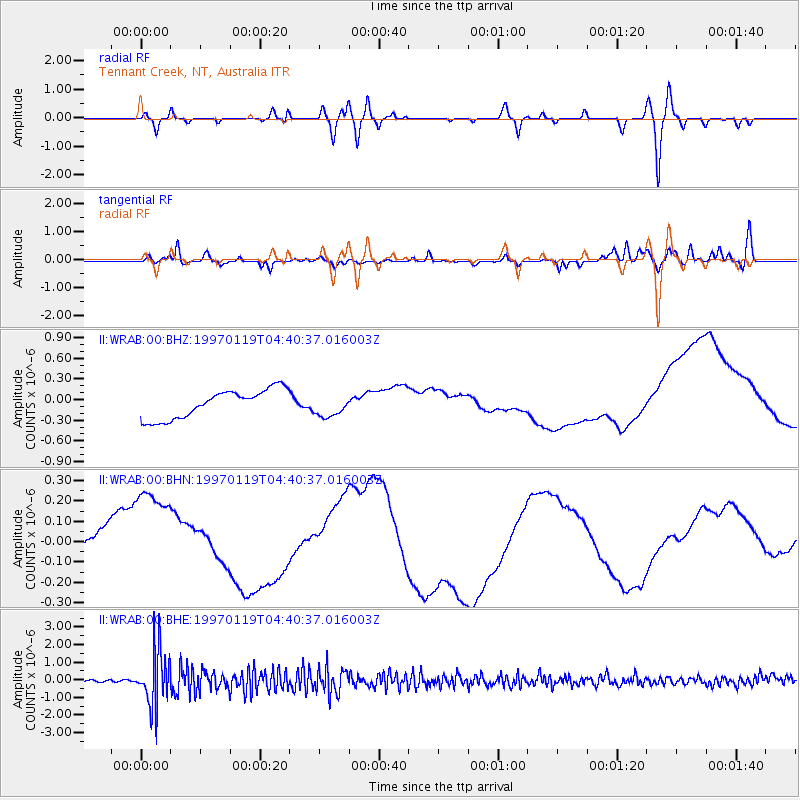
WRAB Tennant Creek, NT, Australia - Earthquake Result Viewer
*The percent match for this event was below the threshold and hence no stack was calculated.
| Earthquake location: |
Philippine Islands Region |
| Earthquake latitude/longitude: |
20.0/121.4 |
| Earthquake time(UTC): |
1997/01/19 (019) 04:33:22 GMT |
| Earthquake Depth: |
33 km |
| Earthquake Magnitude: |
5.7 MB, 5.4 MS, 5.9 UNKNOWN, 5.8 MW |
| Earthquake Catalog/Contributor: |
WHDF/NEIC |
|
| Network: |
II Global Seismograph Network (GSN - IRIS/IDA) |
| Station: |
WRAB Tennant Creek, NT, Australia |
| Lat/Lon: |
19.93 S/134.36 E |
| Elevation: |
366 m |
|
| Distance: |
41.6 deg |
| Az: |
161.514 deg |
| Baz: |
341.52 deg |
| Ray Param: |
$rayparam |
*The percent match for this event was below the threshold and hence was not used in the summary stack. |
|
| Radial Match: |
29.831835 % |
| Radial Bump: |
400 |
| Transverse Match: |
58.18191 % |
| Transverse Bump: |
400 |
| SOD ConfigId: |
4480 |
| Insert Time: |
2010-03-01 23:30:59.865 +0000 |
| GWidth: |
2.5 |
| Max Bumps: |
400 |
| Tol: |
0.001 |
|
Signal To Noise
| Channel | StoN | STA | LTA |
| II:WRAB:00:BHN:19970119T04:40:37.016003Z | 2.0098836 | 2.713985E-7 | 1.3503195E-7 |
| II:WRAB:00:BHE:19970119T04:40:37.016003Z | 15.789934 | 1.589274E-6 | 1.00651086E-7 |
| II:WRAB:00:BHZ:19970119T04:40:37.016003Z | 0.7600927 | 1.585803E-7 | 2.0863285E-7 |
| Arrivals |
| Ps | |
| PpPs | |
| PsPs/PpSs | |


