You are here: Home > Network List > II - Global Seismograph Network (GSN - IRIS/IDA) Stations List
> Station WRAB Tennant Creek, NT, Australia > Earthquake Result Viewer
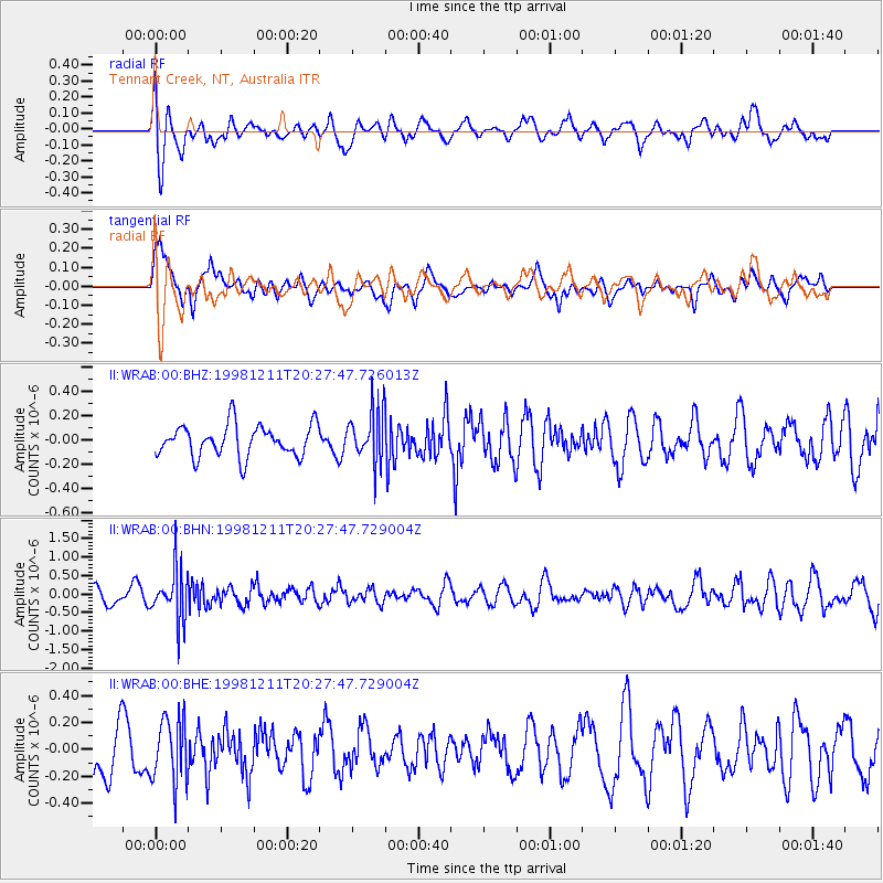
WRAB Tennant Creek, NT, Australia - Earthquake Result Viewer
*The percent match for this event was below the threshold and hence no stack was calculated.
| Earthquake location: |
Afghanistan-Tajikistan Bord Reg. |
| Earthquake latitude/longitude: |
36.5/71.0 |
| Earthquake time(UTC): |
1998/12/11 (345) 20:16:24 GMT |
| Earthquake Depth: |
223 km |
| Earthquake Magnitude: |
5.7 UNKNOWN, 5.0 MB, 5.6 MW |
| Earthquake Catalog/Contributor: |
WHDF/NEIC |
|
| Network: |
II Global Seismograph Network (GSN - IRIS/IDA) |
| Station: |
WRAB Tennant Creek, NT, Australia |
| Lat/Lon: |
19.93 S/134.36 E |
| Elevation: |
366 m |
|
| Distance: |
82.0 deg |
| Az: |
121.89 deg |
| Baz: |
313.36 deg |
| Ray Param: |
$rayparam |
*The percent match for this event was below the threshold and hence was not used in the summary stack. |
|
| Radial Match: |
70.08815 % |
| Radial Bump: |
400 |
| Transverse Match: |
60.41853 % |
| Transverse Bump: |
400 |
| SOD ConfigId: |
4480 |
| Insert Time: |
2010-03-01 23:31:02.357 +0000 |
| GWidth: |
2.5 |
| Max Bumps: |
400 |
| Tol: |
0.001 |
|
Signal To Noise
| Channel | StoN | STA | LTA |
| II:WRAB:00:BHN:19981211T20:27:47.729004Z | 3.3304393 | 7.0613356E-7 | 2.1202413E-7 |
| II:WRAB:00:BHE:19981211T20:27:47.729004Z | 1.2500259 | 2.4120192E-7 | 1.9295753E-7 |
| II:WRAB:00:BHZ:19981211T20:27:47.726013Z | 1.6804743 | 2.1776623E-7 | 1.2958617E-7 |
| Arrivals |
| Ps | |
| PpPs | |
| PsPs/PpSs | |


