You are here: Home > Network List > II - Global Seismograph Network (GSN - IRIS/IDA) Stations List
> Station WRAB Tennant Creek, NT, Australia > Earthquake Result Viewer
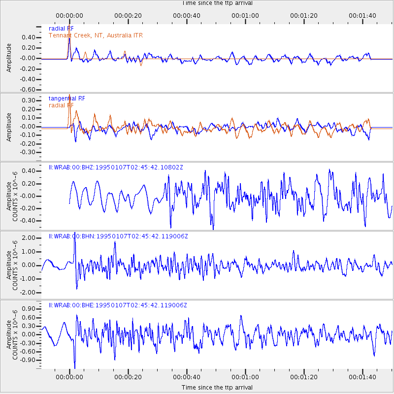
WRAB Tennant Creek, NT, Australia - Earthquake Result Viewer
*The percent match for this event was below the threshold and hence no stack was calculated.
| Earthquake location: |
Near East Coast Of Honshu, Japan |
| Earthquake latitude/longitude: |
40.3/142.4 |
| Earthquake time(UTC): |
1995/01/07 (007) 02:36:08 GMT |
| Earthquake Depth: |
48 km |
| Earthquake Magnitude: |
6.2 MB, 5.6 MS |
| Earthquake Catalog/Contributor: |
WHDF/NEIC |
|
| Network: |
II Global Seismograph Network (GSN - IRIS/IDA) |
| Station: |
WRAB Tennant Creek, NT, Australia |
| Lat/Lon: |
19.93 S/134.36 E |
| Elevation: |
366 m |
|
| Distance: |
60.4 deg |
| Az: |
188.72 deg |
| Baz: |
7.083 deg |
| Ray Param: |
$rayparam |
*The percent match for this event was below the threshold and hence was not used in the summary stack. |
|
| Radial Match: |
58.09264 % |
| Radial Bump: |
400 |
| Transverse Match: |
58.894 % |
| Transverse Bump: |
400 |
| SOD ConfigId: |
4480 |
| Insert Time: |
2010-03-01 23:31:03.556 +0000 |
| GWidth: |
2.5 |
| Max Bumps: |
400 |
| Tol: |
0.001 |
|
Signal To Noise
| Channel | StoN | STA | LTA |
| II:WRAB:00:BHN:19950107T02:45:42.119006Z | 2.759416 | 8.264746E-7 | 2.9951067E-7 |
| II:WRAB:00:BHE:19950107T02:45:42.119006Z | 1.8665284 | 3.9054024E-7 | 2.0923348E-7 |
| II:WRAB:00:BHZ:19950107T02:45:42.10802Z | 1.3761139 | 1.7411463E-7 | 1.2652633E-7 |
| Arrivals |
| Ps | |
| PpPs | |
| PsPs/PpSs | |


