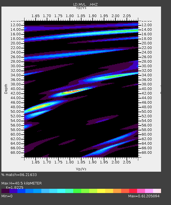
MVL Millersville University, PA - Earthquake Result Viewer

Earthquake location: Rat Islands, Aleutian Islands
Earthquake latitude/longitude: 52.3/176.7
Earthquake time(UTC): 2014/06/24 (175) 03:15:36 GMT
Earthquake Depth: 4.0 km
Earthquake Magnitude: 6.3 MWB, 5.7 ML, 6.4 MWC, 6.6 MI
Earthquake Catalog/Contributor: NEIC PDE/NEIC COMCAT
Network: LD Lamont-Doherty Cooperative Seismographic Network
Station: MVL Millersville University, PA
Lat/Lon: 40.00 N/76.35 W
Elevation: 91 m
Distance: 68.4 deg
Az: 52.198 deg
Baz: 320.778 deg
Ray Param: 0.056312654
Estimated Moho Depth: 40.5 km
Estimated Crust Vp/Vs: 1.82
Assumed Crust Vp: 6.419 km/s
Estimated Crust Vs: 3.522 km/s
Estimated Crust Poisson's Ratio: 0.28
Radial Match: 86.21633 %
Radial Bump: 400
Transverse Match: 69.417145 %
Transverse Bump: 400
SOD ConfigId: 739768
Insert Time: 2014-07-08 03:52:10.984 +0000
GWidth: 2.5
Max Bumps: 400
Tol: 0.001

Signal To Noise

ChannelStoNSTALTA
LD:MVL: :HHZ:20140624T03:26:08.350029Z8.9907885.861708E-76.5196815E-8
LD:MVL: :HHN:20140624T03:26:08.350029Z0.689111651.6914709E-72.4545673E-7
LD:MVL: :HHE:20140624T03:26:08.350029Z0.764373841.4939394E-71.9544616E-7
Arrivals
Ps5.4 SECOND
PpPs17 SECOND
PsPs/PpSs23 SECOND