You are here: Home > Network List > II - Global Seismograph Network (GSN - IRIS/IDA) Stations List
> Station WRAB Tennant Creek, NT, Australia > Earthquake Result Viewer
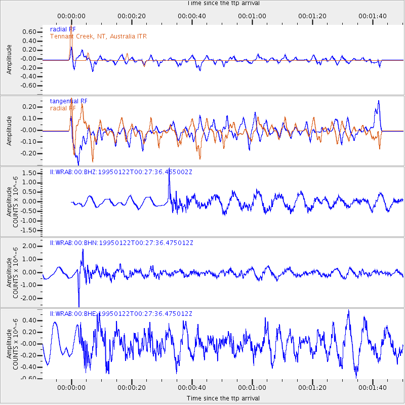
WRAB Tennant Creek, NT, Australia - Earthquake Result Viewer
*The percent match for this event was below the threshold and hence no stack was calculated.
| Earthquake location: |
Fiji Islands Region |
| Earthquake latitude/longitude: |
-20.4/-178.0 |
| Earthquake time(UTC): |
1995/01/22 (022) 00:20:40 GMT |
| Earthquake Depth: |
504 km |
| Earthquake Magnitude: |
5.1 MB, 5.7 UNKNOWN, 5.7 MW |
| Earthquake Catalog/Contributor: |
WHDF/NEIC |
|
| Network: |
II Global Seismograph Network (GSN - IRIS/IDA) |
| Station: |
WRAB Tennant Creek, NT, Australia |
| Lat/Lon: |
19.93 S/134.36 E |
| Elevation: |
366 m |
|
| Distance: |
44.6 deg |
| Az: |
261.948 deg |
| Baz: |
99.152 deg |
| Ray Param: |
$rayparam |
*The percent match for this event was below the threshold and hence was not used in the summary stack. |
|
| Radial Match: |
67.01583 % |
| Radial Bump: |
400 |
| Transverse Match: |
53.741417 % |
| Transverse Bump: |
400 |
| SOD ConfigId: |
4480 |
| Insert Time: |
2010-03-01 23:31:16.064 +0000 |
| GWidth: |
2.5 |
| Max Bumps: |
400 |
| Tol: |
0.001 |
|
Signal To Noise
| Channel | StoN | STA | LTA |
| II:WRAB:00:BHN:19950122T00:27:36.475012Z | 3.1277792 | 7.8419885E-7 | 2.5072063E-7 |
| II:WRAB:00:BHE:19950122T00:27:36.475012Z | 1.05365 | 2.0810721E-7 | 1.9751076E-7 |
| II:WRAB:00:BHZ:19950122T00:27:36.465002Z | 2.688992 | 4.4769766E-7 | 1.6649274E-7 |
| Arrivals |
| Ps | |
| PpPs | |
| PsPs/PpSs | |


