You are here: Home > Network List > N4 - Central and EAstern US Network Stations List
> Station E38A The Farm, Brule, WI, USA > Earthquake Result Viewer
E38A The Farm, Brule, WI, USA - Earthquake Result Viewer
| Earthquake location: |
Rat Islands, Aleutian Islands |
| Earthquake latitude/longitude: |
52.3/176.7 |
| Earthquake time(UTC): |
2014/06/24 (175) 03:15:36 GMT |
| Earthquake Depth: |
4.0 km |
| Earthquake Magnitude: |
6.3 MWB, 5.7 ML, 6.4 MWC, 6.6 MI |
| Earthquake Catalog/Contributor: |
NEIC PDE/NEIC COMCAT |
|
| Network: |
N4 Central and EAstern US Network |
| Station: |
E38A The Farm, Brule, WI, USA |
| Lat/Lon: |
46.61 N/91.55 W |
| Elevation: |
341 m |
|
| Distance: |
56.0 deg |
| Az: |
56.179 deg |
| Baz: |
312.203 deg |
| Ray Param: |
0.064410254 |
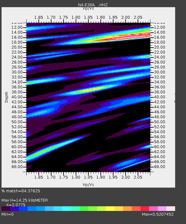
| Estimated Moho Depth: |
14.25 km |
| Estimated Crust Vp/Vs: |
2.08 |
| Assumed Crust Vp: |
6.467 km/s |
| Estimated Crust Vs: |
3.113 km/s |
| Estimated Crust Poisson's Ratio: |
0.35 |
|
| Radial Match: |
84.37625 % |
| Radial Bump: |
400 |
| Transverse Match: |
79.28349 % |
| Transverse Bump: |
400 |
| SOD ConfigId: |
739768 |
| Insert Time: |
2014-07-08 03:55:13.555 +0000 |
| GWidth: |
2.5 |
| Max Bumps: |
400 |
| Tol: |
0.001 |
|

Signal To Noise
| Channel | StoN | STA | LTA |
| N4:E38A: :HHZ:20140624T03:24:45.429985Z | 7.3240995 | 1.0272507E-6 | 1.4025625E-7 |
| N4:E38A: :HHN:20140624T03:24:45.429985Z | 2.355301 | 4.5662958E-7 | 1.9387315E-7 |
| N4:E38A: :HHE:20140624T03:24:45.429985Z | 2.513246 | 3.3369585E-7 | 1.3277484E-7 |
| Arrivals |
| Ps | 2.5 SECOND |
| PpPs | 6.5 SECOND |
| PsPs/PpSs | 9.0 SECOND |


