You are here: Home > Network List > N4 - Central and EAstern US Network Stations List
> Station E46A Sault Ste Marie, MI, USA > Earthquake Result Viewer
E46A Sault Ste Marie, MI, USA - Earthquake Result Viewer
| Earthquake location: |
Rat Islands, Aleutian Islands |
| Earthquake latitude/longitude: |
52.3/176.7 |
| Earthquake time(UTC): |
2014/06/24 (175) 03:15:36 GMT |
| Earthquake Depth: |
4.0 km |
| Earthquake Magnitude: |
6.3 MWB, 5.7 ML, 6.4 MWC, 6.6 MI |
| Earthquake Catalog/Contributor: |
NEIC PDE/NEIC COMCAT |
|
| Network: |
N4 Central and EAstern US Network |
| Station: |
E46A Sault Ste Marie, MI, USA |
| Lat/Lon: |
46.37 N/84.31 W |
| Elevation: |
269 m |
|
| Distance: |
59.8 deg |
| Az: |
52.294 deg |
| Baz: |
315.382 deg |
| Ray Param: |
0.0619455 |
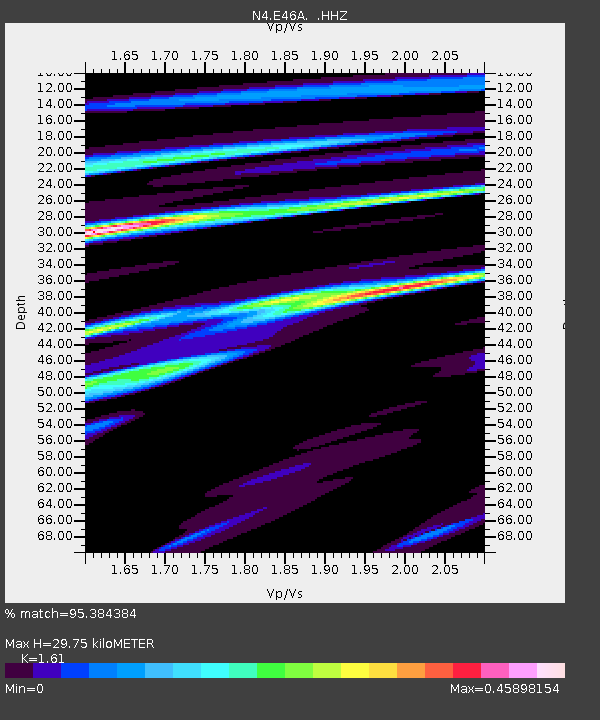
| Estimated Moho Depth: |
29.75 km |
| Estimated Crust Vp/Vs: |
1.61 |
| Assumed Crust Vp: |
6.467 km/s |
| Estimated Crust Vs: |
4.017 km/s |
| Estimated Crust Poisson's Ratio: |
0.19 |
|
| Radial Match: |
95.384384 % |
| Radial Bump: |
336 |
| Transverse Match: |
88.23799 % |
| Transverse Bump: |
400 |
| SOD ConfigId: |
739768 |
| Insert Time: |
2014-07-08 03:55:21.555 +0000 |
| GWidth: |
2.5 |
| Max Bumps: |
400 |
| Tol: |
0.001 |
|

Signal To Noise
| Channel | StoN | STA | LTA |
| N4:E46A: :HHZ:20140624T03:25:11.900017Z | 17.155916 | 1.4510248E-6 | 8.457868E-8 |
| N4:E46A: :HHN:20140624T03:25:11.900017Z | 4.286922 | 5.129832E-7 | 1.1966236E-7 |
| N4:E46A: :HHE:20140624T03:25:11.900017Z | 4.783052 | 5.241151E-7 | 1.0957755E-7 |
| Arrivals |
| Ps | 3.0 SECOND |
| PpPs | 11 SECOND |
| PsPs/PpSs | 14 SECOND |


