You are here: Home > Network List > II - Global Seismograph Network (GSN - IRIS/IDA) Stations List
> Station WRAB Tennant Creek, NT, Australia > Earthquake Result Viewer
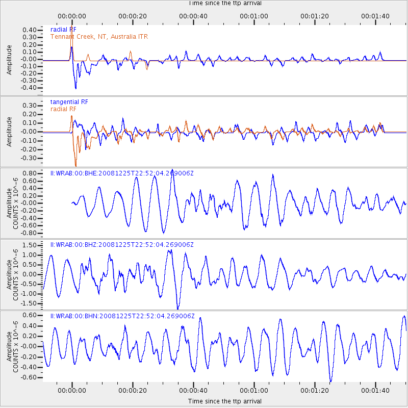
WRAB Tennant Creek, NT, Australia - Earthquake Result Viewer
*The percent match for this event was below the threshold and hence no stack was calculated.
| Earthquake location: |
Off Coast Of Pakistan |
| Earthquake latitude/longitude: |
23.4/64.5 |
| Earthquake time(UTC): |
2008/12/25 (360) 22:40:23 GMT |
| Earthquake Depth: |
13 km |
| Earthquake Magnitude: |
5.8 MB, 5.6 MS, 5.8 MW, 5.8 MW |
| Earthquake Catalog/Contributor: |
WHDF/NEIC |
|
| Network: |
II Global Seismograph Network (GSN - IRIS/IDA) |
| Station: |
WRAB Tennant Creek, NT, Australia |
| Lat/Lon: |
19.93 S/134.36 E |
| Elevation: |
366 m |
|
| Distance: |
80.6 deg |
| Az: |
116.445 deg |
| Baz: |
299.047 deg |
| Ray Param: |
$rayparam |
*The percent match for this event was below the threshold and hence was not used in the summary stack. |
|
| Radial Match: |
58.57949 % |
| Radial Bump: |
400 |
| Transverse Match: |
70.62058 % |
| Transverse Bump: |
378 |
| SOD ConfigId: |
2658 |
| Insert Time: |
2010-03-01 23:31:18.955 +0000 |
| GWidth: |
2.5 |
| Max Bumps: |
400 |
| Tol: |
0.001 |
|
Signal To Noise
| Channel | StoN | STA | LTA |
| II:WRAB:00:BHZ:20081225T22:52:04.269006Z | 1.1111077 | 5.0216323E-7 | 4.5194827E-7 |
| II:WRAB:00:BHN:20081225T22:52:04.269006Z | 0.5392095 | 1.8733714E-7 | 3.4742925E-7 |
| II:WRAB:00:BHE:20081225T22:52:04.269006Z | 1.5915792 | 5.342009E-7 | 3.3564208E-7 |
| Arrivals |
| Ps | |
| PpPs | |
| PsPs/PpSs | |


