You are here: Home > Network List > N4 - Central and EAstern US Network Stations List
> Station T45B Paducah, KY, USA > Earthquake Result Viewer
T45B Paducah, KY, USA - Earthquake Result Viewer
| Earthquake location: |
Rat Islands, Aleutian Islands |
| Earthquake latitude/longitude: |
52.3/176.7 |
| Earthquake time(UTC): |
2014/06/24 (175) 03:15:36 GMT |
| Earthquake Depth: |
4.0 km |
| Earthquake Magnitude: |
6.3 MWB, 5.7 ML, 6.4 MWC, 6.6 MI |
| Earthquake Catalog/Contributor: |
NEIC PDE/NEIC COMCAT |
|
| Network: |
N4 Central and EAstern US Network |
| Station: |
T45B Paducah, KY, USA |
| Lat/Lon: |
37.02 N/88.65 W |
| Elevation: |
136 m |
|
| Distance: |
64.3 deg |
| Az: |
62.259 deg |
| Baz: |
317.174 deg |
| Ray Param: |
0.05899653 |
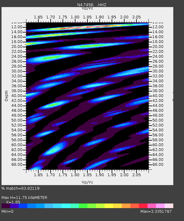
| Estimated Moho Depth: |
11.75 km |
| Estimated Crust Vp/Vs: |
1.85 |
| Assumed Crust Vp: |
6.444 km/s |
| Estimated Crust Vs: |
3.483 km/s |
| Estimated Crust Poisson's Ratio: |
0.29 |
|
| Radial Match: |
83.82119 % |
| Radial Bump: |
400 |
| Transverse Match: |
75.07141 % |
| Transverse Bump: |
400 |
| SOD ConfigId: |
739768 |
| Insert Time: |
2014-07-08 03:57:16.281 +0000 |
| GWidth: |
2.5 |
| Max Bumps: |
400 |
| Tol: |
0.001 |
|

Signal To Noise
| Channel | StoN | STA | LTA |
| N4:T45B: :HHZ:20140624T03:25:42.140007Z | 3.4824238 | 6.827966E-7 | 1.9606937E-7 |
| N4:T45B: :HHN:20140624T03:25:42.140007Z | 2.1341696 | 3.6508956E-7 | 1.7106868E-7 |
| N4:T45B: :HHE:20140624T03:25:42.140007Z | 2.2948344 | 5.0032094E-7 | 2.1802049E-7 |
| Arrivals |
| Ps | 1.6 SECOND |
| PpPs | 5.0 SECOND |
| PsPs/PpSs | 6.6 SECOND |


