You are here: Home > Network List > II - Global Seismograph Network (GSN - IRIS/IDA) Stations List
> Station WRAB Tennant Creek, NT, Australia > Earthquake Result Viewer
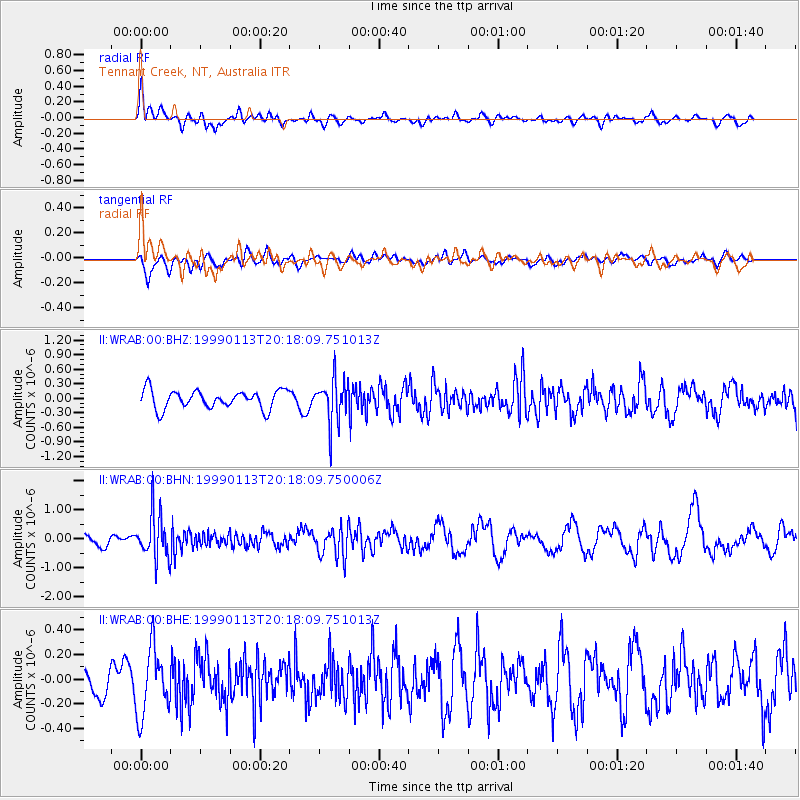
WRAB Tennant Creek, NT, Australia - Earthquake Result Viewer
*The percent match for this event was below the threshold and hence no stack was calculated.
| Earthquake location: |
Vanuatu Islands |
| Earthquake latitude/longitude: |
-20.6/169.8 |
| Earthquake time(UTC): |
1999/01/13 (013) 20:12:15 GMT |
| Earthquake Depth: |
125 km |
| Earthquake Magnitude: |
5.5 MB, 5.9 MW, 5.8 MW |
| Earthquake Catalog/Contributor: |
WHDF/NEIC |
|
| Network: |
II Global Seismograph Network (GSN - IRIS/IDA) |
| Station: |
WRAB Tennant Creek, NT, Australia |
| Lat/Lon: |
19.93 S/134.36 E |
| Elevation: |
366 m |
|
| Distance: |
33.2 deg |
| Az: |
264.832 deg |
| Baz: |
97.374 deg |
| Ray Param: |
$rayparam |
*The percent match for this event was below the threshold and hence was not used in the summary stack. |
|
| Radial Match: |
58.550526 % |
| Radial Bump: |
400 |
| Transverse Match: |
52.012676 % |
| Transverse Bump: |
400 |
| SOD ConfigId: |
4480 |
| Insert Time: |
2010-03-01 23:31:28.691 +0000 |
| GWidth: |
2.5 |
| Max Bumps: |
400 |
| Tol: |
0.001 |
|
Signal To Noise
| Channel | StoN | STA | LTA |
| II:WRAB:00:BHN:19990113T20:18:09.750006Z | 3.1001844 | 7.6814035E-7 | 2.4777248E-7 |
| II:WRAB:00:BHE:19990113T20:18:09.751013Z | 2.4452744 | 2.7034315E-7 | 1.1055739E-7 |
| II:WRAB:00:BHZ:19990113T20:18:09.751013Z | 2.3723412 | 4.486882E-7 | 1.8913309E-7 |
| Arrivals |
| Ps | |
| PpPs | |
| PsPs/PpSs | |


