You are here: Home > Network List > TA - USArray Transportable Network (new EarthScope stations) Stations List
> Station L44A Lake County Forest Preserve, Grayslake, IL, USA > Earthquake Result Viewer
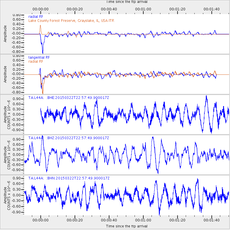
L44A Lake County Forest Preserve, Grayslake, IL, USA - Earthquake Result Viewer
*The percent match for this event was below the threshold and hence no stack was calculated.
| Earthquake location: |
Turkmenistan |
| Earthquake latitude/longitude: |
40.3/52.0 |
| Earthquake time(UTC): |
2015/03/22 (081) 22:45:23 GMT |
| Earthquake Depth: |
31 km |
| Earthquake Magnitude: |
5.1 MW, 5.1 mb, 4.3 MS |
| Earthquake Catalog/Contributor: |
ISC/ISC |
|
| Network: |
TA USArray Transportable Network (new EarthScope stations) |
| Station: |
L44A Lake County Forest Preserve, Grayslake, IL, USA |
| Lat/Lon: |
42.18 N/87.91 W |
| Elevation: |
202 m |
|
| Distance: |
90.3 deg |
| Az: |
331.414 deg |
| Baz: |
29.508 deg |
| Ray Param: |
$rayparam |
*The percent match for this event was below the threshold and hence was not used in the summary stack. |
|
| Radial Match: |
79.79179 % |
| Radial Bump: |
400 |
| Transverse Match: |
73.00634 % |
| Transverse Bump: |
400 |
| SOD ConfigId: |
7422571 |
| Insert Time: |
2019-04-17 21:15:19.713 +0000 |
| GWidth: |
2.5 |
| Max Bumps: |
400 |
| Tol: |
0.001 |
|
Signal To Noise
| Channel | StoN | STA | LTA |
| TA:L44A: :BHZ:20150322T22:57:49.900017Z | 2.2678788 | 6.323618E-7 | 2.7883402E-7 |
| TA:L44A: :BHN:20150322T22:57:49.900017Z | 1.1400522 | 2.438196E-7 | 2.1386705E-7 |
| TA:L44A: :BHE:20150322T22:57:49.900017Z | 2.1813073 | 5.270918E-7 | 2.4164032E-7 |
| Arrivals |
| Ps | |
| PpPs | |
| PsPs/PpSs | |


