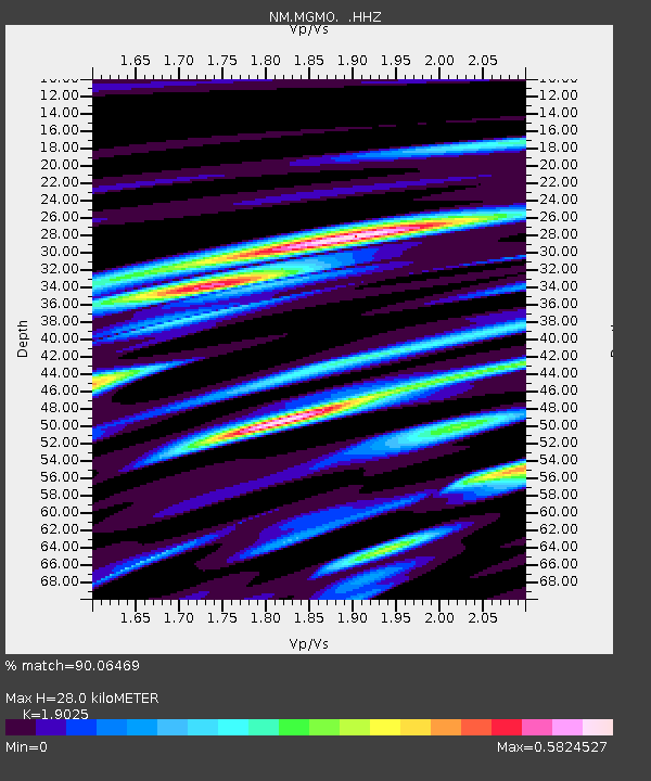
MGMO Mountain Grove, MO - Earthquake Result Viewer

Earthquake location: Rat Islands, Aleutian Islands
Earthquake latitude/longitude: 52.3/176.7
Earthquake time(UTC): 2014/06/24 (175) 03:15:36 GMT
Earthquake Depth: 4.0 km
Earthquake Magnitude: 6.3 MWB, 5.7 ML, 6.4 MWC, 6.6 MI
Earthquake Catalog/Contributor: NEIC PDE/NEIC COMCAT
Network: NM Cooperative New Madrid Seismic Network
Station: MGMO Mountain Grove, MO
Lat/Lon: 37.15 N/92.27 W
Elevation: 453 m
Distance: 62.2 deg
Az: 64.509 deg
Baz: 316.01 deg
Ray Param: 0.060364094
Estimated Moho Depth: 28.0 km
Estimated Crust Vp/Vs: 1.90
Assumed Crust Vp: 6.53 km/s
Estimated Crust Vs: 3.433 km/s
Estimated Crust Poisson's Ratio: 0.31
Radial Match: 90.06469 %
Radial Bump: 400
Transverse Match: 67.67266 %
Transverse Bump: 400
SOD ConfigId: 739768
Insert Time: 2014-07-08 04:01:26.242 +0000
GWidth: 2.5
Max Bumps: 400
Tol: 0.001

Signal To Noise

ChannelStoNSTALTA
NM:MGMO: :HHZ:20140624T03:25:28.307976Z5.5454785.3409394E-79.6311624E-8
NM:MGMO: :HHN:20140624T03:25:28.307976Z2.87138532.5475032E-78.8720356E-8
NM:MGMO: :HHE:20140624T03:25:28.307976Z3.52140021.9406663E-75.5110643E-8
Arrivals
Ps4.0 SECOND
PpPs12 SECOND
PsPs/PpSs16 SECOND