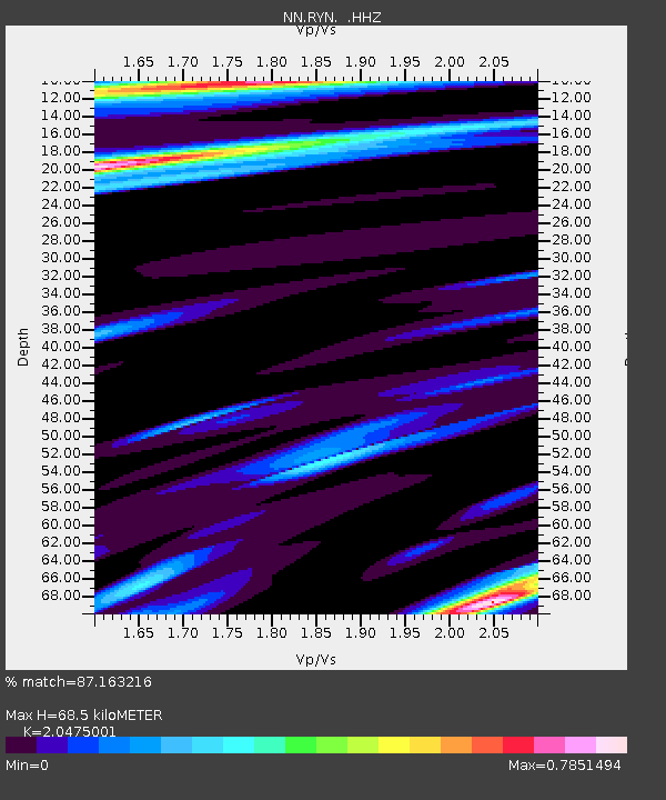
RYN Ryan, Nevada w84,gps - Earthquake Result Viewer

Earthquake location: Rat Islands, Aleutian Islands
Earthquake latitude/longitude: 52.3/176.7
Earthquake time(UTC): 2014/06/24 (175) 03:15:36 GMT
Earthquake Depth: 4.0 km
Earthquake Magnitude: 6.3 MWB, 5.7 ML, 6.4 MWC, 6.6 MI
Earthquake Catalog/Contributor: NEIC PDE/NEIC COMCAT
Network: NN Western Great Basin/Eastern Sierra Nevada
Station: RYN Ryan, Nevada w84,gps
Lat/Lon: 38.63 N/118.52 W
Elevation: 1651 m
Distance: 45.9 deg
Az: 80.482 deg
Baz: 309.279 deg
Ray Param: 0.07097992
Estimated Moho Depth: 68.5 km
Estimated Crust Vp/Vs: 2.05
Assumed Crust Vp: 6.279 km/s
Estimated Crust Vs: 3.066 km/s
Estimated Crust Poisson's Ratio: 0.34
Radial Match: 87.163216 %
Radial Bump: 316
Transverse Match: 67.29654 %
Transverse Bump: 400
SOD ConfigId: 739768
Insert Time: 2014-07-08 04:02:28.045 +0000
GWidth: 2.5
Max Bumps: 400
Tol: 0.001

Signal To Noise

ChannelStoNSTALTA
NN:RYN: :HHZ:20140624T03:23:29.349999Z4.55135444.6321156E-71.0177444E-7
NN:RYN: :HHN:20140624T03:23:29.349999Z2.10256121.5453192E-77.349699E-8
NN:RYN: :HHE:20140624T03:23:29.349999Z4.38290363.4574686E-77.888535E-8
Arrivals
Ps12 SECOND
PpPs32 SECOND
PsPs/PpSs44 SECOND