You are here: Home > Network List > II - Global Seismograph Network (GSN - IRIS/IDA) Stations List
> Station WRAB Tennant Creek, NT, Australia > Earthquake Result Viewer
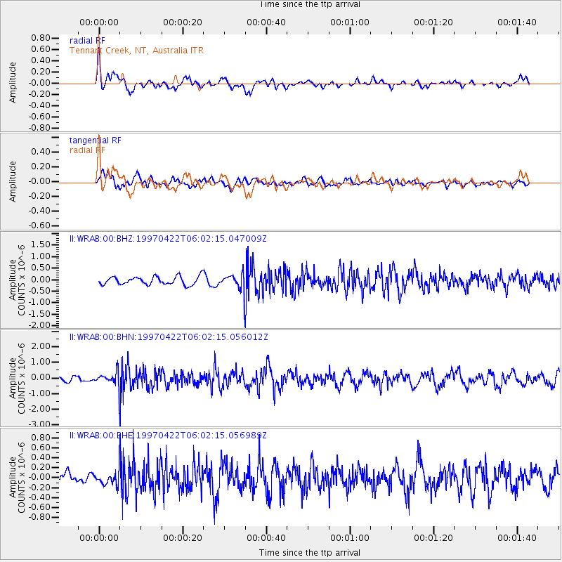
WRAB Tennant Creek, NT, Australia - Earthquake Result Viewer
*The percent match for this event was below the threshold and hence no stack was calculated.
| Earthquake location: |
Southern Sumatra, Indonesia |
| Earthquake latitude/longitude: |
-3.4/102.1 |
| Earthquake time(UTC): |
1997/04/22 (112) 05:55:59 GMT |
| Earthquake Depth: |
108 km |
| Earthquake Magnitude: |
5.6 MB, 5.9 UNKNOWN, 5.9 MW |
| Earthquake Catalog/Contributor: |
WHDF/NEIC |
|
| Network: |
II Global Seismograph Network (GSN - IRIS/IDA) |
| Station: |
WRAB Tennant Creek, NT, Australia |
| Lat/Lon: |
19.93 S/134.36 E |
| Elevation: |
366 m |
|
| Distance: |
35.5 deg |
| Az: |
120.195 deg |
| Baz: |
293.491 deg |
| Ray Param: |
$rayparam |
*The percent match for this event was below the threshold and hence was not used in the summary stack. |
|
| Radial Match: |
65.71346 % |
| Radial Bump: |
400 |
| Transverse Match: |
69.02424 % |
| Transverse Bump: |
400 |
| SOD ConfigId: |
4480 |
| Insert Time: |
2010-03-01 23:31:35.157 +0000 |
| GWidth: |
2.5 |
| Max Bumps: |
400 |
| Tol: |
0.001 |
|
Signal To Noise
| Channel | StoN | STA | LTA |
| II:WRAB:00:BHN:19970422T06:02:15.056012Z | 1.4895067 | 4.558723E-7 | 3.060559E-7 |
| II:WRAB:00:BHE:19970422T06:02:15.056989Z | 0.7690231 | 1.3888085E-7 | 1.8059386E-7 |
| II:WRAB:00:BHZ:19970422T06:02:15.047009Z | 2.0725965 | 3.6502723E-7 | 1.7612074E-7 |
| Arrivals |
| Ps | |
| PpPs | |
| PsPs/PpSs | |


