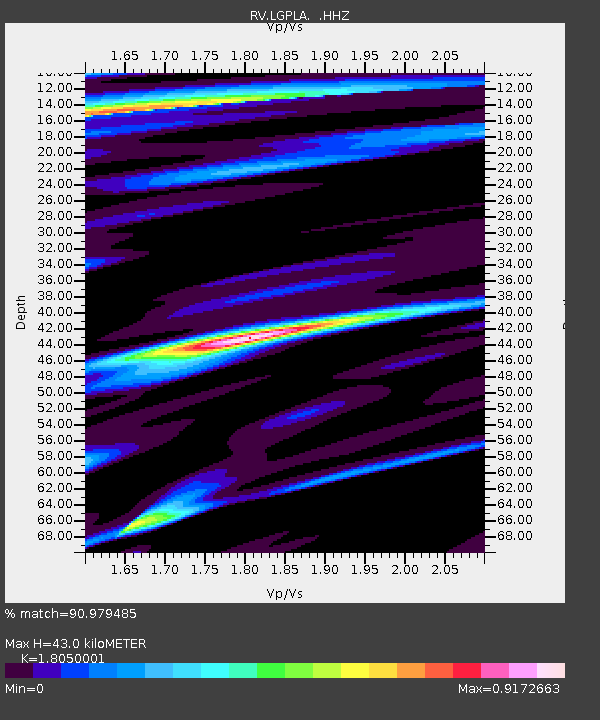
LGPLA Lodgepole, Alberta - Earthquake Result Viewer

Earthquake location: Rat Islands, Aleutian Islands
Earthquake latitude/longitude: 52.3/176.7
Earthquake time(UTC): 2014/06/24 (175) 03:15:36 GMT
Earthquake Depth: 4.0 km
Earthquake Magnitude: 6.3 MWB, 5.7 ML, 6.4 MWC, 6.6 MI
Earthquake Catalog/Contributor: NEIC PDE/NEIC COMCAT
Network: RV Regional Alberta Seismic Observatory for Earthquake Studies Network
Station: LGPLA Lodgepole, Alberta
Lat/Lon: 53.12 N/115.36 W
Elevation: 877 m
Distance: 39.8 deg
Az: 60.824 deg
Baz: 297.065 deg
Ray Param: 0.07480459
Estimated Moho Depth: 43.0 km
Estimated Crust Vp/Vs: 1.81
Assumed Crust Vp: 6.426 km/s
Estimated Crust Vs: 3.56 km/s
Estimated Crust Poisson's Ratio: 0.28
Radial Match: 90.979485 %
Radial Bump: 400
Transverse Match: 78.16114 %
Transverse Bump: 400
SOD ConfigId: 739768
Insert Time: 2014-07-08 04:07:11.451 +0000
GWidth: 2.5
Max Bumps: 400
Tol: 0.001

Signal To Noise

ChannelStoNSTALTA
RV:LGPLA: :HHZ:20140624T03:22:39.589989Z5.52184341.3514959E-62.4475446E-7
RV:LGPLA: :HHN:20140624T03:22:39.589989Z1.91373173.38536E-71.7689838E-7
RV:LGPLA: :HHE:20140624T03:22:39.589989Z3.03891235.6814656E-71.8695721E-7
Arrivals
Ps5.8 SECOND
PpPs18 SECOND
PsPs/PpSs23 SECOND